
Topografische kaart New Hampshire
Interactieve kaart
Klik op de kaart om de hoogte weer te geven.
Over deze kaart
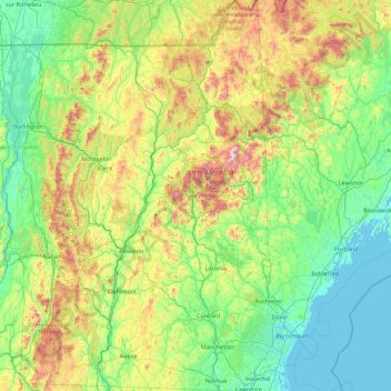
Naam: Topografische kaart New Hampshire, hoogte, reliëf.
Locatie: New Hampshire, United States (42.69723 -72.55724 45.30578 -70.56136)
Gemiddelde hoogte: 293 m
Minimale hoogte: -4 m
Maximale hoogte: 1.693 m
Average daytime highs are in the mid 70s°F to low 80s°F (24–28 °C) throughout the state in July, with overnight lows in the mid 50s°F to low 60s°F (13–15 °C). January temperatures range from an average high of 34 °F (1 °C) on the coast to overnight lows below 0 °F (−18 °C) in the far north and at high elevations. Average annual precipitation statewide is roughly 40 inches (100 cm) with some variation occurring in the White Mountains due to differences in elevation and annual snowfall. New Hampshire's highest recorded temperature was 106 °F (41 °C) in Nashua on July 4, 1911, while the lowest recorded temperature was −47 °F (−44 °C) atop Mount Washington on January 29, 1934. Mount Washington also saw an unofficial −50 °F (−46 °C) reading on January 22, 1885, which, if made official, would tie the record low for New England (also −50 °F (−46 °C) at Big Black River, Maine, on January 16, 2009, and Bloomfield, Vermont on December 30, 1933).
Andere topografische kaarten
Klik op een kaart om zijn topografie, zijn hoogte en zijn reliëf te bekijken.
Houston
United States > Texas > Harris County
Houston, Harris County, Texas, United States
Gemiddelde hoogte: 25 m
Montgomery County
Montgomery County, Texas, United States
Gemiddelde hoogte: 69 m
The Woodlands
United States > Texas > Montgomery County
The Woodlands, Montgomery County, Texas, United States
Gemiddelde hoogte: 47 m
Boulder
United States > Colorado > Boulder County
Boulder, Boulder County, Colorado, United States
Gemiddelde hoogte: 1.785 m
Brooklyn
United States > New York > New York
Brooklyn, Kings County, New York, United States
Gemiddelde hoogte: 9 m
Knoxville
United States > Tennessee > Knox County
Knoxville, Knox County, East Tennessee, Tennessee, United States
Gemiddelde hoogte: 307 m
New Orleans
United States > Louisiana > Orleans Parish
New Orleans, Orleans Parish, Louisiana, United States
Gemiddelde hoogte: 1 m
Appalachian Mountains
United States > North Carolina > Yancey County
Appalachian Mountains, Yancey County, North Carolina, United States
Gemiddelde hoogte: 1.463 m
Santa Barbara
United States > California > Santa Barbara County
Santa Barbara, Santa Barbara County, California, United States
Gemiddelde hoogte: 119 m
Sequoia National Park
United States > California > Tulare County
Sequoia National Park, Tulare County, California, United States
Gemiddelde hoogte: 2.515 m
Brunswick County
United States > North Carolina
Brunswick County, North Carolina, United States
Gemiddelde hoogte: 9 m
Yosemite National Park
Yosemite National Park, California, United States
Gemiddelde hoogte: 2.337 m
Black Hills
United States > South Dakota > Pennington County
Black Hills, Pennington County, South Dakota, United States
Gemiddelde hoogte: 1.894 m
Hillsborough County
Hillsborough County, Florida, United States
Gemiddelde hoogte: 20 m
Queens County
United States > New York > New York
Queens County, New York, United States
Gemiddelde hoogte: 11 m
Spokane
United States > Washington > Spokane County
Spokane, Spokane County, Washington, United States
Gemiddelde hoogte: 655 m
Boston
United States > Massachusetts > Suffolk County
Boston, Suffolk County, Massachusetts, United States
Gemiddelde hoogte: 25 m