
Topografische kaart Iowa
Interactieve kaart
Klik op de kaart om de hoogte weer te geven.
Over deze kaart
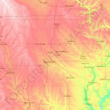
Naam: Topografische kaart Iowa, hoogte, reliëf.
Locatie: Iowa, United States (40.37560 -96.63972 43.50116 -90.14006)
Gemiddelde hoogte: 316 m
Minimale hoogte: 129 m
Maximale hoogte: 602 m
Iowa can be divided into eight landforms based on glaciation, soils, topography, and river drainage. Loess hills lie along the western border of the state, some of which are several hundred feet thick. Northeast Iowa along the Upper Mississippi River is part of the Driftless Area, consisting of steep hills and valleys which appear as mountainous.
Andere topografische kaarten
Klik op een kaart om zijn topografie, zijn hoogte en zijn reliëf te bekijken.
Houston
United States > Texas > Harris County
Houston, Harris County, Texas, United States
Gemiddelde hoogte: 25 m
Montgomery County
Montgomery County, Texas, United States
Gemiddelde hoogte: 69 m
Los Angeles
Los Angeles, Los Angeles County, California, United States
Gemiddelde hoogte: 241 m
The Woodlands
United States > Texas > Montgomery County
The Woodlands, Montgomery County, Texas, United States
Gemiddelde hoogte: 47 m
Fernandina Beach
United States > Florida > Nassau County
Fernandina Beach, Nassau County, Florida, 32035, United States
Gemiddelde hoogte: 2 m
Highlands Ranch
United States > Colorado > Douglas County
Highlands Ranch, Douglas County, Colorado, 80126, United States
Gemiddelde hoogte: 1.758 m
Brooklyn
United States > New York > New York
Brooklyn, Kings County, New York, United States
Gemiddelde hoogte: 9 m
Tomball
United States > Texas > Harris County
Tomball, Harris County, Texas, 77375, United States
Gemiddelde hoogte: 52 m
Boulder
United States > Colorado > Boulder County
Boulder, Boulder County, Colorado, United States
Gemiddelde hoogte: 1.785 m
New Orleans
United States > Louisiana > Orleans Parish
New Orleans, Orleans Parish, Louisiana, United States
Gemiddelde hoogte: 1 m
Fort Worth
United States > Texas > Tarrant County
Fort Worth, Tarrant County, Texas, United States
Gemiddelde hoogte: 212 m
Middle East
United States > Maryland > Baltimore
Middle East, Baltimore, Maryland, United States
Gemiddelde hoogte: 29 m
Lansing
United States > Michigan > Ingham County
Lansing, Ingham County, Michigan, United States
Gemiddelde hoogte: 263 m
Hudson River
Hudson River, New Jersey, 12834:12871, United States
Gemiddelde hoogte: 297 m
Appalachian Mountains
United States > North Carolina > Yancey County
Appalachian Mountains, Yancey County, North Carolina, United States
Gemiddelde hoogte: 1.463 m
College Station
United States > Texas > Brazos County
College Station, Brazos County, Texas, United States
Gemiddelde hoogte: 87 m
Albuquerque
United States > New Mexico > Bernalillo County
Albuquerque, Bernalillo County, New Mexico, United States
Gemiddelde hoogte: 1.688 m
Jacksonville
United States > Florida > Duval County
Jacksonville, Duval County, Florida, United States
Gemiddelde hoogte: 10 m
Castle Rock
United States > Colorado > Douglas County
Castle Rock, Douglas County, Colorado, United States
Gemiddelde hoogte: 1.952 m