
Topografische kaart Alabama
Interactieve kaart
Klik op de kaart om de hoogte weer te geven.
Over deze kaart
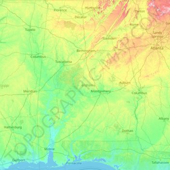
Naam: Topografische kaart Alabama, hoogte, reliëf.
Locatie: Alabama, United States (30.14338 -88.47310 35.00811 -84.88829)
Gemiddelde hoogte: 136 m
Minimale hoogte: -3 m
Maximale hoogte: 1.232 m
Alabama is bordered by the states of Tennessee to the north, Georgia to the east, Florida to the south, and Mississippi to the west. Alabama has coastline at the Gulf of Mexico, in the extreme southern edge of the state. The state ranges in elevation from sea level at Mobile Bay to more than 2,000 feet (610 m) in the northeast, to Mount Cheaha at 2,413 ft (735 m).
Andere topografische kaarten
Klik op een kaart om zijn topografie, zijn hoogte en zijn reliëf te bekijken.
Houston
United States > Texas > Harris County
Houston, Harris County, Texas, United States
Gemiddelde hoogte: 25 m
Montgomery County
Montgomery County, Texas, United States
Gemiddelde hoogte: 69 m
Los Angeles
Los Angeles, Los Angeles County, California, United States
Gemiddelde hoogte: 241 m
Hillsborough County
Hillsborough County, Florida, United States
Gemiddelde hoogte: 20 m
Fall River
United States > Massachusetts > Bristol County
Fall River, Bristol County, Massachusetts, United States
Gemiddelde hoogte: 32 m
Camano Island
United States > Washington > Island County
Camano Island, Island County, Washington, 98282, United States
Gemiddelde hoogte: 27 m
Brooklyn
United States > New York > New York
Brooklyn, Kings County, New York, United States
Gemiddelde hoogte: 9 m
The Woodlands
United States > Texas > Montgomery County
The Woodlands, Montgomery County, Texas, United States
Gemiddelde hoogte: 47 m
Fort Worth
United States > Texas > Tarrant County
Fort Worth, Tarrant County, Texas, United States
Gemiddelde hoogte: 212 m
Fernandina Beach
United States > Florida > Nassau County
Fernandina Beach, Nassau County, Florida, 32035, United States
Gemiddelde hoogte: 2 m
Rudyard
United States > Michigan > Chippewa County
Rudyard, Rudyard Township, Chippewa County, Michigan, United States
Gemiddelde hoogte: 209 m
College Station
United States > Texas > Brazos County
College Station, Brazos County, Texas, United States
Gemiddelde hoogte: 87 m
Sierra Nevada
United States > California > Tulare County
Sierra Nevada, Tulare County, California, United States
Gemiddelde hoogte: 3.888 m
New Orleans
United States > Louisiana > Orleans Parish
New Orleans, Orleans Parish, Louisiana, United States
Gemiddelde hoogte: 1 m
Highlands Ranch
United States > Colorado > Douglas County
Highlands Ranch, Douglas County, Colorado, 80126, United States
Gemiddelde hoogte: 1.758 m
Tomball
United States > Texas > Harris County
Tomball, Harris County, Texas, 77375, United States
Gemiddelde hoogte: 52 m
Albuquerque
United States > New Mexico > Bernalillo County
Albuquerque, Bernalillo County, New Mexico, United States
Gemiddelde hoogte: 1.688 m
Sonoma County
Sonoma County, California, United States
Gemiddelde hoogte: 210 m
Boulder
United States > Colorado > Boulder County
Boulder, Boulder County, Colorado, United States
Gemiddelde hoogte: 1.785 m
Middle East
United States > Maryland > Baltimore
Middle East, Baltimore, Maryland, United States
Gemiddelde hoogte: 29 m
Lansing
United States > Michigan > Ingham County
Lansing, Ingham County, Michigan, United States
Gemiddelde hoogte: 263 m