
Topografische kaart South Carolina
Interactieve kaart
Klik op de kaart om de hoogte weer te geven.
Over deze kaart
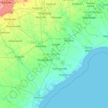
Naam: Topografische kaart South Carolina, hoogte, reliëf.
Locatie: South Carolina, United States (32.03345 -83.35400 35.21549 -78.54135)
Gemiddelde hoogte: 85 m
Minimale hoogte: -4 m
Maximale hoogte: 1.642 m
The Atlantic Coastal plain consists of sediments and sedimentary rocks that range in age from Cretaceous to Present. The terrain is relatively flat and the soil is composed predominantly of sand, silt, and clay. Areas with better drainage make excellent farmland, though some land is swampy. An unusual feature of the coastal plain is a large number of low-relief topographic depressions named Carolina bays. The bays tend to be oval, lining up in a northwest to southeast orientation. The eastern portion of the coastal plain contains many salt marshes and estuaries, as well as natural ports such as Georgetown and Charleston. The natural areas of the coastal plain are part of the Middle Atlantic coastal forests ecoregion.
Andere topografische kaarten
Klik op een kaart om zijn topografie, zijn hoogte en zijn reliëf te bekijken.
Houston
United States > Texas > Harris County
Houston, Harris County, Texas, United States
Gemiddelde hoogte: 25 m
Montgomery County
Montgomery County, Texas, United States
Gemiddelde hoogte: 69 m
Los Angeles
Los Angeles, Los Angeles County, California, United States
Gemiddelde hoogte: 241 m
The Woodlands
United States > Texas > Montgomery County
The Woodlands, Montgomery County, Texas, United States
Gemiddelde hoogte: 47 m
Brooklyn
United States > New York > New York
Brooklyn, Kings County, New York, United States
Gemiddelde hoogte: 9 m
New Orleans
United States > Louisiana > Orleans Parish
New Orleans, Orleans Parish, Louisiana, United States
Gemiddelde hoogte: 1 m
Appalachian Mountains
United States > North Carolina > Yancey County
Appalachian Mountains, Yancey County, North Carolina, United States
Gemiddelde hoogte: 1.463 m
Hudson River
Hudson River, New Jersey, 12834:12871, United States
Gemiddelde hoogte: 297 m
Albuquerque
United States > New Mexico > Bernalillo County
Albuquerque, Bernalillo County, New Mexico, United States
Gemiddelde hoogte: 1.688 m
Boulder
United States > Colorado > Boulder County
Boulder, Boulder County, Colorado, United States
Gemiddelde hoogte: 1.785 m
Jacksonville
United States > Florida > Duval County
Jacksonville, Duval County, Florida, United States
Gemiddelde hoogte: 10 m
College Station
United States > Texas > Brazos County
College Station, Brazos County, Texas, United States
Gemiddelde hoogte: 87 m
Hillsborough County
Hillsborough County, Florida, United States
Gemiddelde hoogte: 20 m
Spokane
United States > Washington > Spokane County
Spokane, Spokane County, Washington, United States
Gemiddelde hoogte: 655 m
Tampa
United States > Florida > Hillsborough County
Tampa, Hillsborough County, Florida, United States
Gemiddelde hoogte: 11 m
Middle East
United States > Maryland > Baltimore
Middle East, Baltimore, Maryland, United States
Gemiddelde hoogte: 29 m
Missoula
United States > Montana > Missoula County
Missoula, Missoula County, Montana, United States
Gemiddelde hoogte: 1.173 m
Santa Fe
United States > New Mexico > Santa Fe County
Santa Fe, Santa Fe County, New Mexico, United States
Gemiddelde hoogte: 2.221 m
San Luis Obispo
United States > California > San Luis Obispo County
San Luis Obispo, San Luis Obispo County, CAL Fire Southern Region, California, United States
Gemiddelde hoogte: 133 m