
Topografische kaart Minnesota
Interactieve kaart
Klik op de kaart om de hoogte weer te geven.
Over deze kaart
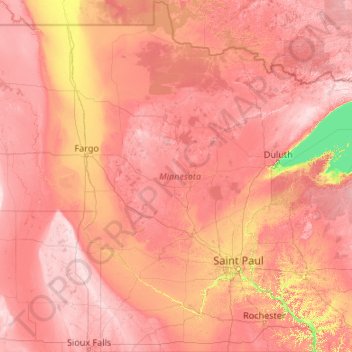
Naam: Topografische kaart Minnesota, hoogte, reliëf.
Locatie: Minnesota, United States (43.49943 -97.23926 49.38447 -89.48339)
Gemiddelde hoogte: 378 m
Minimale hoogte: 176 m
Maximale hoogte: 678 m
The state's high point is Eagle Mountain at 2,301 feet (701 m), which is only 13 miles (21 km) away from the low point of 601 feet (183 m) at the shore of Lake Superior. Notwithstanding dramatic local differences in elevation, much of the state is a gently rolling peneplain.
Andere topografische kaarten
Klik op een kaart om zijn topografie, zijn hoogte en zijn reliëf te bekijken.
Houston
United States > Texas > Harris County
Houston, Harris County, Texas, United States
Gemiddelde hoogte: 25 m
Boulder
United States > Colorado > Boulder County
Boulder, Boulder County, Colorado, United States
Gemiddelde hoogte: 1.785 m
Montgomery County
Montgomery County, Texas, United States
Gemiddelde hoogte: 69 m
Los Angeles
Los Angeles, Los Angeles County, California, United States
Gemiddelde hoogte: 241 m
The Woodlands
United States > Texas > Montgomery County
The Woodlands, Montgomery County, Texas, United States
Gemiddelde hoogte: 47 m
Brooklyn
United States > New York > New York
Brooklyn, Kings County, New York, United States
Gemiddelde hoogte: 9 m
Queens County
United States > New York > New York
Queens County, New York, United States
Gemiddelde hoogte: 11 m
Fort Worth
United States > Texas > Tarrant County
Fort Worth, Tarrant County, Texas, United States
Gemiddelde hoogte: 212 m
Boston
United States > Massachusetts > Suffolk County
Boston, Suffolk County, Massachusetts, United States
Gemiddelde hoogte: 25 m
New Orleans
United States > Louisiana > Orleans Parish
New Orleans, Orleans Parish, Louisiana, United States
Gemiddelde hoogte: 1 m
Fall River
United States > Massachusetts > Bristol County
Fall River, Bristol County, Massachusetts, United States
Gemiddelde hoogte: 32 m
Saint Johns County
Saint Johns County, Florida, United States
Gemiddelde hoogte: 6 m
Tomball
United States > Texas > Harris County
Tomball, Harris County, Texas, 77375, United States
Gemiddelde hoogte: 52 m
Sequoia National Park
United States > California > Tulare County
Sequoia National Park, Tulare County, California, United States
Gemiddelde hoogte: 2.515 m
Hillsborough County
Hillsborough County, Florida, United States
Gemiddelde hoogte: 20 m
Hudson River
Hudson River, New Jersey, 12834:12871, United States
Gemiddelde hoogte: 297 m
Albuquerque
United States > New Mexico > Bernalillo County
Albuquerque, Bernalillo County, New Mexico, United States
Gemiddelde hoogte: 1.688 m