
Topografische kaart West Virginia
Interactieve kaart
Klik op de kaart om de hoogte weer te geven.
Over deze kaart
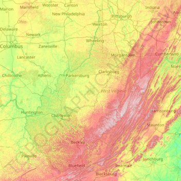
Naam: Topografische kaart West Virginia, hoogte, reliëf.
Locatie: West Virginia, United States (37.20141 -82.64474 40.63880 -77.71903)
Gemiddelde hoogte: 430 m
Minimale hoogte: 84 m
Maximale hoogte: 1.452 m
West Virginia is located entirely within the Appalachian Region, and the state is almost entirely mountainous, giving the reason for the nickname The Mountain State and the motto Montani Semper Liberi ("Mountaineers are always free"). The elevations and ruggedness drop near large rivers like the Ohio River or Shenandoah River. About 75% of the state is within the Cumberland Plateau and Allegheny Plateau regions. Though the relief is not high, the plateau region is extremely rugged in most areas. The average elevation of West Virginia is approximately 1,500 feet (460 m) above sea level, which is the highest of any U.S. state east of the Mississippi River.
Andere topografische kaarten
Klik op een kaart om zijn topografie, zijn hoogte en zijn reliëf te bekijken.
Houston
United States > Texas > Harris County
Houston, Harris County, Texas, United States
Gemiddelde hoogte: 25 m
Boulder
United States > Colorado > Boulder County
Boulder, Boulder County, Colorado, United States
Gemiddelde hoogte: 1.785 m
Montgomery County
Montgomery County, Texas, United States
Gemiddelde hoogte: 69 m
Los Angeles
Los Angeles, Los Angeles County, California, United States
Gemiddelde hoogte: 241 m
The Woodlands
United States > Texas > Montgomery County
The Woodlands, Montgomery County, Texas, United States
Gemiddelde hoogte: 47 m
Spokane
United States > Washington > Spokane County
Spokane, Spokane County, Washington, United States
Gemiddelde hoogte: 655 m
Lancaster County
Lancaster County, Pennsylvania, United States
Gemiddelde hoogte: 158 m
Hudson River
Hudson River, New Jersey, 12834:12871, United States
Gemiddelde hoogte: 297 m
Fort Worth
United States > Texas > Tarrant County
Fort Worth, Tarrant County, Texas, United States
Gemiddelde hoogte: 212 m
Brooklyn
United States > New York > New York
Brooklyn, Kings County, New York, United States
Gemiddelde hoogte: 9 m
New Orleans
United States > Louisiana > Orleans Parish
New Orleans, Orleans Parish, Louisiana, United States
Gemiddelde hoogte: 1 m
Sequoia National Park
United States > California > Tulare County
Sequoia National Park, Tulare County, California, United States
Gemiddelde hoogte: 2.515 m
Tomball
United States > Texas > Harris County
Tomball, Harris County, Texas, 77375, United States
Gemiddelde hoogte: 52 m
Queens County
United States > New York > New York
Queens County, New York, United States
Gemiddelde hoogte: 11 m
Black Hills
United States > South Dakota > Pennington County
Black Hills, Pennington County, South Dakota, United States
Gemiddelde hoogte: 1.894 m
Saint Johns County
Saint Johns County, Florida, United States
Gemiddelde hoogte: 6 m