
Topografische kaart Indiana
Interactieve kaart
Klik op de kaart om de hoogte weer te geven.
Over deze kaart
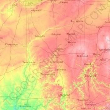
Naam: Topografische kaart Indiana, hoogte, reliëf.
Locatie: Indiana, United States (37.77174 -88.09970 41.76137 -84.78461)
Gemiddelde hoogte: 226 m
Minimale hoogte: 103 m
Maximale hoogte: 458 m
The average altitude of Indiana is about 760 feet (230 m) above sea level. The highest point in the state is Hoosier Hill in Wayne County at 1,257 feet (383 m) above sea level. The lowest point at 320 feet (98 m) above sea level is in Posey County, where the Wabash River meets the Ohio River. The resulting elevation span, 937 feet (286 m), is the narrowest of any non-coastal U.S. state. Only 2,850 square miles (7,400 km2) have an altitude greater than 1,000 feet (300 m) and this area is enclosed within 14 counties. About 4,700 square miles (12,000 km2) have an elevation of less than 500 feet (150 m), mostly concentrated along the Ohio and lower Wabash Valleys, from Tell City and Terre Haute to Evansville and Mount Vernon.
Andere topografische kaarten
Klik op een kaart om zijn topografie, zijn hoogte en zijn reliëf te bekijken.
Houston
United States > Texas > Harris County
Houston, Harris County, Texas, United States
Gemiddelde hoogte: 25 m
Montgomery County
Montgomery County, Texas, United States
Gemiddelde hoogte: 69 m
Los Angeles
Los Angeles, Los Angeles County, California, United States
Gemiddelde hoogte: 241 m
The Woodlands
United States > Texas > Montgomery County
The Woodlands, Montgomery County, Texas, United States
Gemiddelde hoogte: 47 m
Tomball
United States > Texas > Harris County
Tomball, Harris County, Texas, 77375, United States
Gemiddelde hoogte: 52 m
Hillsborough County
Hillsborough County, Florida, United States
Gemiddelde hoogte: 20 m
New Orleans
United States > Louisiana > Orleans Parish
New Orleans, Orleans Parish, Louisiana, United States
Gemiddelde hoogte: 1 m
Fall River
United States > Massachusetts > Bristol County
Fall River, Bristol County, Massachusetts, United States
Gemiddelde hoogte: 32 m
Camano Island
United States > Washington > Island County
Camano Island, Island County, Washington, 98282, United States
Gemiddelde hoogte: 27 m
Brooklyn
United States > New York > New York
Brooklyn, Kings County, New York, United States
Gemiddelde hoogte: 9 m
Saint Thomas
United States > United States Virgin Islands > Saint Thomas - Saint John District > Charlotte Amalie
Saint Thomas, Charlotte Amalie, Saint Thomas - Saint John District, United States Virgin Islands, United States
Gemiddelde hoogte: 15 m
Fort Lauderdale
United States > Florida > Broward County
Fort Lauderdale, Broward County, Florida, United States
Gemiddelde hoogte: 5 m
Fort Worth
United States > Texas > Tarrant County
Fort Worth, Tarrant County, Texas, United States
Gemiddelde hoogte: 212 m
Fernandina Beach
United States > Florida > Nassau County
Fernandina Beach, Nassau County, Florida, 32035, United States
Gemiddelde hoogte: 2 m
Rudyard
United States > Michigan > Chippewa County
Rudyard, Rudyard Township, Chippewa County, Michigan, United States
Gemiddelde hoogte: 209 m
College Station
United States > Texas > Brazos County
College Station, Brazos County, Texas, United States
Gemiddelde hoogte: 87 m
Sierra Nevada
United States > California > Tulare County
Sierra Nevada, Tulare County, California, United States
Gemiddelde hoogte: 3.888 m
Shasta County
Shasta County, California, United States
Gemiddelde hoogte: 1.053 m
Middle East
United States > Maryland > Baltimore
Middle East, Baltimore, Maryland, United States
Gemiddelde hoogte: 29 m
Highlands Ranch
United States > Colorado > Douglas County
Highlands Ranch, Douglas County, Colorado, 80126, United States
Gemiddelde hoogte: 1.758 m