
Doe een donatie
Rust jezelf uit voor je volgende avontuur:
Als Amazon-partner verdient deze site een commissie op in aanmerking komende aankopen, zonder extra kosten voor jou.
Topografische kaart Central Greece
Klik op de kaart om de hoogte weer te geven.
Doe een donatie
Rust jezelf uit voor je volgende avontuur:
Als Amazon-partner verdient deze site een commissie op in aanmerking komende aankopen, zonder extra kosten voor jou.
Over deze kaart
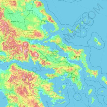
Naam: Topografische kaart Central Greece, hoogte, reliëf.
Locatie: Central Greece, Thessaly and Central Greece, Greece (37.85238 21.37393 39.27322 24.78599)
Gemiddelde hoogte: 263 m
Minimale hoogte: -5 m
Maximale hoogte: 2.487 m
Doe een donatie
Rust jezelf uit voor je volgende avontuur:
Als Amazon-partner verdient deze site een commissie op in aanmerking komende aankopen, zonder extra kosten voor jou.
Andere topografische kaarten
Klik op een kaart om zijn topografie, zijn hoogte en zijn reliëf te bekijken.
Athens
Greece > Attica > Regional Unit of Central Athens
Owing to the rain shadow of the Pindus Mountains, annual precipitation of Athens is lower than most other parts of Greece, especially western Greece. As an example, Ioannina receives around 1,300 mm (51 in) per year, and Agrinio around 800 mm (31 in) per year. Daily average highs for July have been measured…
Gemiddelde hoogte: 168 m
Corfu
Greece > Peloponnese, Western Greece and the Ionian > Corfu Regional Unit
Gemiddelde hoogte: 66 m
Doe een donatie
Rust jezelf uit voor je volgende avontuur:
Als Amazon-partner verdient deze site een commissie op in aanmerking komende aankopen, zonder extra kosten voor jou.
Knossos Palace
Greece > Region of Crete > Heraklion Regional Unit > Heraklion Municipal Unit
The identification of Knossos with the Bronze Age site is supported by the Roman coins that were scattered over the fields surrounding the pre-excavation site, then a large mound named Kephala Hill, elevation 85 m (279 ft) from current sea level. Many of them were inscribed with Knosion or Knos on the obverse…
Gemiddelde hoogte: 151 m
Agni Beach
Greece > Ioanian Islands > Corfu Regional Unit > Kassopaia Municipal Unit > Kentroma > Agni
Gemiddelde hoogte: 77 m
Doe een donatie
Rust jezelf uit voor je volgende avontuur:
Als Amazon-partner verdient deze site een commissie op in aanmerking komende aankopen, zonder extra kosten voor jou.
Πόρτες
Greece > Western Greece > Achaia Regional Unit > Municipal Unit of Olenia
Gemiddelde hoogte: 314 m
Κάτω Γύρη-Άγ.Ονούφριος-Ρίζες (Αρκάσας-Μενετών Καρπάθου)
Greece > South Aegean > Karpathos-Kasos Regional Unit > Karpathos Municipal Unit > Menetes
Gemiddelde hoogte: 231 m
Vasiliki
Greece > Ioanian Islands > Lefkada Regional Unit > Municipal Unit of Apollonioi
Gemiddelde hoogte: 114 m
Ioannina
Greece > Epirus > Ioannina Regional Unit
Ioannina (Greek: Ιωάννινα Ioánnina [i.oˈa.ni.na] (listen)), often called Yannena (Γιάννενα Yánnena [ˈʝa.ne.na]) within Greece, is the capital and largest city of the Ioannina regional unit and of Epirus, an administrative region in north-western Greece. According to the 2011 census, the…
Gemiddelde hoogte: 724 m
Doe een donatie
Rust jezelf uit voor je volgende avontuur:
Als Amazon-partner verdient deze site een commissie op in aanmerking komende aankopen, zonder extra kosten voor jou.
Agios Konstantinos
Greece > Northern Aegean > Samos Regional Unit > Municipal Unit of Vathy
Gemiddelde hoogte: 135 m
Nikiti
Greece > Central Macedonia > Chalkidiki Regional Unit > Sithonia Municipal Unit
Gemiddelde hoogte: 64 m
Doe een donatie
Rust jezelf uit voor je volgende avontuur:
Als Amazon-partner verdient deze site een commissie op in aanmerking komende aankopen, zonder extra kosten voor jou.
Koroni
Greece > Peloponnese, Western Greece and the Ionian > Messenia Regional Unit > Koroni Municipal Unit
Between 1966 and 1989 a facility for launching sounding rockets was established near the town. The first launches were performed from Koroni on May 20, 1966 for investigation an annular solar eclipse. These rockets reached an altitude of 114 kilometers. From 1972 to 1989 several Russian meteorological rockets…
Gemiddelde hoogte: 27 m
Doe een donatie
Rust jezelf uit voor je volgende avontuur:
Als Amazon-partner verdient deze site een commissie op in aanmerking komende aankopen, zonder extra kosten voor jou.
Athens
Greece > Attica > Regional Unit of Central Athens
Owing to the rain shadow of the Pindus Mountains, annual precipitation of Athens is lower than most other parts of Greece, especially western Greece. As an example, Ioannina receives around 1,300 mm (51 in) per year, and Agrinio around 800 mm (31 in) per year. Daily average highs for July have been measured…
Gemiddelde hoogte: 168 m
Doe een donatie
Rust jezelf uit voor je volgende avontuur:
Als Amazon-partner verdient deze site een commissie op in aanmerking komende aankopen, zonder extra kosten voor jou.
Ρίζα
Greece > Region of Crete > Lasithi Regional Unit > Ierapetra Municipal Unit
Gemiddelde hoogte: 553 m
Thebes
Greece > Central Greece > Regional Unit of Boeotia > Municipal Unit of Thebes
Thebes is situated in a plain, between Lake Yliki (ancient Hylica) to the north, and the Cithaeron mountains, which divide Boeotia from Attica, to the south. Its elevation is 215 m (705 ft) above mean sea level. It is about 50 km (31 mi) northwest of Athens, and 100 km (62 mi) southeast of Lamia. The A1…
Gemiddelde hoogte: 218 m
Pinios
Greece > Western Greece > Elis Regional Unit > Municipality of Pyrgos > Σιτοχώρι
Gemiddelde hoogte: 412 m
Patras
Greece > Peloponnese, Western Greece and the Ionian > Achaia Regional Unit
A central feature of the urban geography of Patras is its division into upper and lower sections. This is the result of an interplay between natural geography and human settlement patterns; the lower section of the city (Kato Poli), which includes the 19th-century urban core and the port, is adjacent to the…
Gemiddelde hoogte: 283 m
Doe een donatie
Rust jezelf uit voor je volgende avontuur:
Als Amazon-partner verdient deze site een commissie op in aanmerking komende aankopen, zonder extra kosten voor jou.
Karpenisi
Greece > Central Greece > Regional Unit of Evrytania > Municipal Unit of Karpenisi
Karpenisi (Greek: Καρπενήσι, Greek pronunciation: [karpeˈnisi]) is a town in central Greece. It is the capital of the regional unit of Evrytania. Karpenisi lies within the valley of the river Karpenisiotis (Καρπενησιώτης), a tributary of the Megdovas, in the southern part of the Pindus…
Gemiddelde hoogte: 1.236 m
Αγία Παρασκευή
Greece > Central Macedonia > Chalkidiki Regional Unit > Pallini Municipal Unit
Gemiddelde hoogte: 165 m
Doe een donatie
Rust jezelf uit voor je volgende avontuur:
Als Amazon-partner verdient deze site een commissie op in aanmerking komende aankopen, zonder extra kosten voor jou.
Sisi
Greece > Region of Crete > Lasithi Regional Unit > Vrachasi Municipal Unit
Gemiddelde hoogte: 58 m
Komotini
Greece > Eastern Macedonia and Thrace > Rodopi Regional Unit
The city stands at an altitude of 32-38m on the Thracian plain near the foothills of the Rhodope Mountains. It is situated between two rivers, Boklutzas on the west and Trelohimaros on the east (which form, alongside the Karidia stream, the river Bosbozis). There is little urban planning in the older parts of…
Gemiddelde hoogte: 231 m
Doe een donatie
Rust jezelf uit voor je volgende avontuur:
Als Amazon-partner verdient deze site een commissie op in aanmerking komende aankopen, zonder extra kosten voor jou.
Drimea
Greece > Central Greece > Phthiotis Regional Unit > Municipal Unit of Amfiklia
Gemiddelde hoogte: 588 m
Kalamaki Beach
Greece > Peloponnese, Western Greece and the Ionian > Zakynthos Regional Unit > Laganas Municipal Unit
Gemiddelde hoogte: 32 m
Doe een donatie
Rust jezelf uit voor je volgende avontuur:
Als Amazon-partner verdient deze site een commissie op in aanmerking komende aankopen, zonder extra kosten voor jou.
Meteora
Greece > Thessaly > Trikala Regional Unit > Kastraki
The Monastery of Rousanou is believed to have been constructed, like many of the other monasteries, in the 14th century. The cathedral is believed to have been built in the 16th century and later decorated in 1540. The name Rousanou is believed to come from the first group of monks who settled on the rock from…
Gemiddelde hoogte: 429 m
Ermioni
Greece > Peloponnese, Western Greece and the Ionian > Argolis Regional Unit > Municipal Unit of Ermioni
Gemiddelde hoogte: 55 m
Stemnitsa
Greece > Peloponnese, Western Greece and the Ionian > Arcadia Regional Unit > Municipal Unit of Trikolonoi
Stemnitsa (Greek: Στεμνίτσα) is a mountain village in the municipal unit of Trikolonoi, Arcadia, Peloponnese, Greece. It was the seat of the former municipality Trikolonoi. Stemnitsa is a traditional settlement and is considered one of the most beautiful villages in Arcadia, due to its picturesque…
Gemiddelde hoogte: 1.166 m
Doe een donatie
Rust jezelf uit voor je volgende avontuur:
Als Amazon-partner verdient deze site een commissie op in aanmerking komende aankopen, zonder extra kosten voor jou.
Karpenisi
Greece > Central Greece > Regional Unit of Evrytania > Municipal Unit of Karpenisi
Karpenisi (Greek: Καρπενήσι, Greek pronunciation: [karpeˈnisi]) is a town in central Greece. It is the capital of the regional unit of Evrytania. Karpenisi lies within the valley of the river Karpenisiotis (Καρπενησιώτης), a tributary of the Megdovas, in the southern part of the Pindus…
Gemiddelde hoogte: 1.236 m
Argos
Greece > Peloponnese, Western Greece and the Ionian > Argolis Regional Unit
Gemiddelde hoogte: 322 m
Doe een donatie
Rust jezelf uit voor je volgende avontuur:
Als Amazon-partner verdient deze site een commissie op in aanmerking komende aankopen, zonder extra kosten voor jou.
Pylos
Greece > Peloponnese Region > Messenia Regional Unit
The erection of this fort led to one of the most memorable events in the Peloponnesian War. Thucydides has given a minute account of the topography of the district, which, though clear and consistent with itself, does not coincide, in all points, with the existing locality, Thucydides describes the harbour, of…
Gemiddelde hoogte: 79 m
Archanes
Greece > Region of Crete > Heraklion Regional Unit > Archanes Municipal Unit
Gemiddelde hoogte: 333 m
Doe een donatie
Rust jezelf uit voor je volgende avontuur:
Als Amazon-partner verdient deze site een commissie op in aanmerking komende aankopen, zonder extra kosten voor jou.
Πρόδρομος
Greece > Thessaly and Central Greece > Regional Unit of Boeotia > Δημοτική Ενότητα Θίσβης
Gemiddelde hoogte: 368 m
Athens
Greece > Attica > Regional Unit of Central Athens
The southern section of the Athens metropolitan area (i.e., Elliniko, Athens Riviera) lies in the transitional zone between Mediterranean (Csa) and hot semi-arid climate (BSh), with its port-city of Piraeus being the most extreme example, receiving just 331.9 millimetres (13.07 in) per year. The areas to the…
Gemiddelde hoogte: 168 m
Pindus
Greece > Thessaly and Central Greece > Karditsa Regional Unit
The Pindus, also Pindos or Pindhos is a mountain range located in Northern Greece and Southern Albania. It is roughly 160 km (99 mi) long, with a maximum elevation of 2,637 metres (8,652 ft) (Mount Smolikas). Because it runs north to south along much of mainland Greece, the Pindus range is known colloquially…
Gemiddelde hoogte: 1.510 m
Doe een donatie
Rust jezelf uit voor je volgende avontuur:
Als Amazon-partner verdient deze site een commissie op in aanmerking komende aankopen, zonder extra kosten voor jou.
Artemida
Greece > Attica > Regional Unit of East Attica > Artemida Municipal Unit
Gemiddelde hoogte: 38 m
Derveni
Greece > Macedonia and Thrace > Thessaloniki Regional Unit > Mygdonia Municipal Unit > Λητή
Gemiddelde hoogte: 234 m
Doe een donatie
Rust jezelf uit voor je volgende avontuur:
Als Amazon-partner verdient deze site een commissie op in aanmerking komende aankopen, zonder extra kosten voor jou.
Neos Marmaras
Greece > Macedonia and Thrace > Chalkidiki Regional Unit > Sithonia Municipal Unit
Gemiddelde hoogte: 89 m
Tolo
Greece > Peloponnese Region > Argolis Regional Unit > Municipal Unit of Asini
Gemiddelde hoogte: 44 m
Epitalio
Greece > Western Greece > Elis Regional Unit > Municipality of Pyrgos
Gemiddelde hoogte: 24 m
Doe een donatie
Rust jezelf uit voor je volgende avontuur:
Als Amazon-partner verdient deze site een commissie op in aanmerking komende aankopen, zonder extra kosten voor jou.
Ξηροκάμπι
Greece > Peloponnese, Western Greece and the Ionian > Arcadia Regional Unit
Gemiddelde hoogte: 923 m
Chania
Greece > Region of Crete > Chania Regional Unit
The climate in Chania is further complemented due to the terrain and can vary throughout its regions and elevations and according to its topography. At the south lies the mountain range of Lefka Ori. Furthermore, prevailing winds, such as those of the West side and South of Crete, in addition to the North…
Gemiddelde hoogte: 194 m
Doe een donatie
Rust jezelf uit voor je volgende avontuur:
Als Amazon-partner verdient deze site een commissie op in aanmerking komende aankopen, zonder extra kosten voor jou.
Vrachasi
Greece > Region of Crete > Lasithi Regional Unit > Vrachasi Municipal Unit
Gemiddelde hoogte: 363 m
Doe een donatie
Rust jezelf uit voor je volgende avontuur:
Als Amazon-partner verdient deze site een commissie op in aanmerking komende aankopen, zonder extra kosten voor jou.
Vikos–Aoos National Park
Greece > Epirus > Ioannina Regional Unit
The Vikos–Aoös National Park (Greek: Εθνικός Δρυμός Βίκου–Αώου, romanized: Ethnikós Drymós Víkou–Aóou) is a national park in the region of Epirus in northwestern Greece. The park, founded in 1973, is one of ten national parks in mainland Greece and is located 30 kilometres (19…
Gemiddelde hoogte: 1.147 m
Imera
Greece > Epirus and Western Macedonia > Kozani Regional Unit > Servia Municipal Unit
Gemiddelde hoogte: 418 m
Palaio Faliro
Greece > Attica > Regional Unit of South Athens
Phaleron was an important place in antiquity, then as now one of the demes of Athens; however, a precise definition of its Classical topography is lacking, although the location of the deme is well established. Pausanias records that it was on the coast, equidistant from Athens and Cape Kolias (i.e., Ayios…
Gemiddelde hoogte: 27 m
Doe een donatie
Rust jezelf uit voor je volgende avontuur:
Als Amazon-partner verdient deze site een commissie op in aanmerking komende aankopen, zonder extra kosten voor jou.
Athens
Greece > Attica > Regional Unit of Central Athens
The southern section of the Athens metropolitan area (i.e., Elliniko, Athens Riviera) lies in the transitional zone between Mediterranean (Csa) and hot semi-arid climate (BSh), with its port-city of Piraeus being the most extreme example, receiving just 331.9 millimetres (13.07 in) per year. The areas to the…
Gemiddelde hoogte: 168 m
Taygeti
Greece > Peloponnese Region > Laconia Regional Unit > Municipal Unit of Mystras
Gemiddelde hoogte: 806 m
Doe een donatie
Rust jezelf uit voor je volgende avontuur:
Als Amazon-partner verdient deze site een commissie op in aanmerking komende aankopen, zonder extra kosten voor jou.
Ancient Olympia
Greece > Peloponnese, Western Greece and the Ionian > Elis Regional Unit > Municipal Unit of Archea Olympia
Another location that has a special interest to both ancients and moderns is the stadium. It is basically a field with start and end lines marked off by transverse curbing. The athletes entered under an archway of a vaulted corridor at the start. Spectators sat mainly on the field's sloping flanks. The length…
Gemiddelde hoogte: 99 m
Serres
Greece > Macedonia and Thrace > Serres Regional Unit
Serres is one of the administrative and economic centers of Northern Greece. The city is situated in a fertile plain at an elevation of about 70 metres (230 feet), some 24 kilometres (15 miles) northeast of the Strymon river and 69 km (43 mi) north-east of Thessaloniki, respectively. Serres' official municipal…
Gemiddelde hoogte: 317 m
Hymettus
Greece > Attica > Regional Unit of Central Athens
The highest point of the mountain range is Evzonas (Εύζωνας) with an elevation of 1,026 m (3,366 ft). The 16 km (9.9 mi) length of Hymettus stretches from Athens to the Saronic Gulf. It is 6 to 7 km from east to west. In ancient times, the highest point was known as Megas Hymettos and the southern peaks…
Gemiddelde hoogte: 680 m
Doe een donatie
Rust jezelf uit voor je volgende avontuur:
Als Amazon-partner verdient deze site een commissie op in aanmerking komende aankopen, zonder extra kosten voor jou.
Mátala
Greece > Region of Crete > Heraklion Regional Unit > Tybakio Municipal Unit
Gemiddelde hoogte: 56 m
Eretria
Greece > Central Greece > Euboea Regional Unit > Eretria Municipal Unit
Gemiddelde hoogte: 45 m
Magouliana
Greece > Peloponnese Region > Arcadia Regional Unit > Municipal Unit of Vytina
Gemiddelde hoogte: 1.176 m
Doe een donatie
Rust jezelf uit voor je volgende avontuur:
Als Amazon-partner verdient deze site een commissie op in aanmerking komende aankopen, zonder extra kosten voor jou.
Leontio
Greece > Peloponnese Region > Corinthia Regional Unit > Municipality of Nemea
Gemiddelde hoogte: 456 m
Eleusis
Greece > Attica > Regional Unit of West Attica > Municipal Unit of Elefsina
Gemiddelde hoogte: 30 m
Charakas
Greece > Region of Crete > Heraklion Regional Unit > Asterousia Municipal Unit
The community of Charakas (Δημοτική Κοινότητα Χάρακος) consists of the village Charakas and the smaller villages Agia Fotia (Αγιά Φωτιά) (pop. 22, at elevation 275 m, 2 km to the West from Charakas) and Doraki (Δωράκι) (pop. 24, at elevation 310 m, 1.5 km to the East from Charakas).
Gemiddelde hoogte: 357 m
Doe een donatie
Rust jezelf uit voor je volgende avontuur:
Als Amazon-partner verdient deze site een commissie op in aanmerking komende aankopen, zonder extra kosten voor jou.
Naoussa
Greece > Macedonia and Thrace > Imathia Regional Unit
Naousa is located in Northwestern Imathia, 22 kilometers north of Veria and 90 kilometers west of Thessaloniki. The city lies on the eastern foothills of Vermio Mountains, one of the biggest mountain ranges in Greece, and west to the plain of Giannitsa. Naousa is today the largest forest-owning municipality in…
Gemiddelde hoogte: 652 m
Corinth
Greece > Peloponnese, Western Greece and the Ionian > Corinthia Regional Unit
Gemiddelde hoogte: 21 m
Doe een donatie
Rust jezelf uit voor je volgende avontuur:
Als Amazon-partner verdient deze site een commissie op in aanmerking komende aankopen, zonder extra kosten voor jou.
Serres
Greece > Central Macedonia > Serres Regional Unit
Serres is one of the administrative and economic centers of Northern Greece. The city is situated in a fertile plain at an elevation of about 70 metres (230 feet), some 24 kilometres (15 miles) northeast of the Strymon river and 69 km (43 mi) north-east of Thessaloniki, respectively. Serres' official municipal…
Gemiddelde hoogte: 317 m
Doe een donatie
Rust jezelf uit voor je volgende avontuur:
Als Amazon-partner verdient deze site een commissie op in aanmerking komende aankopen, zonder extra kosten voor jou.