
Topografische kaart Philopappos Hill
Interactieve kaart
Klik op de kaart om de hoogte weer te geven.
Over deze kaart
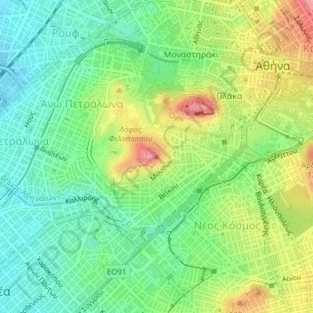
Naam: Topografische kaart Philopappos Hill, hoogte, reliëf.
Gemiddelde hoogte: 73 m
Minimale hoogte: 27 m
Maximale hoogte: 148 m
Andere topografische kaarten
Klik op een kaart om zijn topografie, zijn hoogte en zijn reliëf te bekijken.
Lycabettus
Greece > Attica > Regional Unit of Central Athens > Athens
Lycabettus, Δώρας Δ' Ίστρια, Kolonaki, Συνοικία Κολωνακίου, 1st District of Athens, Athens, Municipality of Athens, Regional Unit of Central Athens, Attica, 106 76, Greece
Gemiddelde hoogte: 125 m
Dourgouti Region
Greece > Attica > Regional Unit of Central Athens > Athens
Dourgouti Region, Dourgouti, 2nd District of Athens, Athens, Municipality of Athens, Regional Unit of Central Athens, Attica, Greece
Gemiddelde hoogte: 73 m
Άλσος Βεΐκου
Greece > Attica > Regional Unit of Central Athens > Athens
Άλσος Βεΐκου, Galatsi, Athens, Municipality of Galatsi, Regional Unit of Central Athens, Attica, Greece
Gemiddelde hoogte: 171 m
Ιλισσός
Greece > Attica > Regional Unit of Central Athens > Athens
Ιλισσός, 7th District of Athens, Athens, Municipality of Athens, Regional Unit of Central Athens, Attica, 11527, Greece
Gemiddelde hoogte: 140 m