
Doe een donatie
Rust jezelf uit voor je volgende avontuur:
Als Amazon-partner verdient deze site een commissie op in aanmerking komende aankopen, zonder extra kosten voor jou.
Topografische kaart Corfu
Klik op de kaart om de hoogte weer te geven.
Doe een donatie
Rust jezelf uit voor je volgende avontuur:
Als Amazon-partner verdient deze site een commissie op in aanmerking komende aankopen, zonder extra kosten voor jou.
Over deze kaart
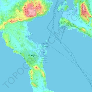
Naam: Topografische kaart Corfu, hoogte, reliëf.
Gemiddelde hoogte: 66 m
Minimale hoogte: -7 m
Maximale hoogte: 894 m
Doe een donatie
Rust jezelf uit voor je volgende avontuur:
Als Amazon-partner verdient deze site een commissie op in aanmerking komende aankopen, zonder extra kosten voor jou.
Andere topografische kaarten
Klik op een kaart om zijn topografie, zijn hoogte en zijn reliëf te bekijken.
Corfu
Greece > Ioanian Islands > Corfu Regional Unit
Two high and well-defined ranges divide the island into three districts, of which the northern is mountainous, the central undulating, and the southern low-lying. The more important of the two ranges, that of Pantokrator (Παντοκράτωρ – the Almighty) stretches east and west from Cape Falacro to…
Gemiddelde hoogte: 41 m
Agni Beach
Greece > Ioanian Islands > Corfu Regional Unit > Kassopaia Municipal Unit > Kentroma > Agni
Gemiddelde hoogte: 77 m
Othonoi
Greece > Ioanian Islands > Corfu Regional Unit > Othonoi Municipal Unit
At the beginning of the second millennium, the island was conquered alternatively by the Franks (the 11th century) and the Venetians (12th century), and often attacked by pirates of Barbary and Algeria. From the end of 1383 until 1386 the domination of Corfu was held by Charles III of Naples. In a letter from…
Gemiddelde hoogte: 49 m
Corfu
Greece > Ioanian Islands > Corfu Regional Unit
Two high, well-defined ranges divide the island into three districts: the northern is mountainous, the central undulating, and the southern low-lying. The more important of the two ranges, that of Pantokrator (Παντοκράτωρ – the Almighty) stretches east and west from Cape Falacro to Cape Psaromita,…
Gemiddelde hoogte: 41 m
Doe een donatie
Rust jezelf uit voor je volgende avontuur:
Als Amazon-partner verdient deze site een commissie op in aanmerking komende aankopen, zonder extra kosten voor jou.
Corfu
Greece > Ioanian Islands > Corfu Regional Unit
Two high and well-defined ranges divide the island into three districts, of which the northern is mountainous, the central undulating, and the southern low-lying. The more important of the two ranges, that of Pantokrator (Παντοκράτωρ – the Almighty) stretches east and west from Cape Falacro to…
Gemiddelde hoogte: 41 m