
Doe een donatie
Rust jezelf uit voor je volgende avontuur:
Als Amazon-partner verdient deze site een commissie op in aanmerking komende aankopen, zonder extra kosten voor jou.
Topografische kaart Stemnitsa
Klik op de kaart om de hoogte weer te geven.
Doe een donatie
Rust jezelf uit voor je volgende avontuur:
Als Amazon-partner verdient deze site een commissie op in aanmerking komende aankopen, zonder extra kosten voor jou.
Stemnitsa
Stemnitsa (Greek: Στεμνίτσα) is a mountain village in the municipal unit of Trikolonoi, Arcadia, Peloponnese, Greece. It was the seat of the former municipality Trikolonoi. Stemnitsa is a traditional settlement and is considered one of the most beautiful villages in Arcadia, due to its picturesque location and its historical churches and mansions. It is situated at the western edge of the Mainalo mountains, above the left bank of the river Lousios, at about 1050 m elevation. Stemnitsa is 6 km southeast of Dimitsana, 9 km northeast of Karytaina, 18 km northwest of Megalopoli and 26 km west of Tripoli. In 2011 Stemnitsa had a population of 191.
Doe een donatie
Rust jezelf uit voor je volgende avontuur:
Als Amazon-partner verdient deze site een commissie op in aanmerking komende aankopen, zonder extra kosten voor jou.
Over deze kaart
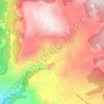
Naam: Topografische kaart Stemnitsa, hoogte, reliëf.
Gemiddelde hoogte: 1.166 m
Minimale hoogte: 455 m
Maximale hoogte: 1.546 m
Doe een donatie
Rust jezelf uit voor je volgende avontuur:
Als Amazon-partner verdient deze site een commissie op in aanmerking komende aankopen, zonder extra kosten voor jou.