
Topografische kaart East Riding of Yorkshire
Interactieve kaart
Klik op de kaart om de hoogte weer te geven.
Over deze kaart
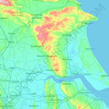
Naam: Topografische kaart East Riding of Yorkshire, hoogte, reliëf.
Locatie: East Riding of Yorkshire, England, United Kingdom (53.57059 -1.10357 54.17652 0.14983)
Gemiddelde hoogte: 30 m
Minimale hoogte: -2 m
Maximale hoogte: 302 m
The western part of the district in the Vale of York borders on and is drained by the River Derwent. The landscape is generally low-lying and flat although minor ridges and glacial moraines provide some variations in topography. Where there are dry sandy soils there are remnants of historic heathlands and ancient semi-natural woodlands. Arable fields dominate the land cover of the area and grasslands are infrequent. There are very few flood meadows left, although some significant areas remain on the lower reaches of the River Derwent.
Andere topografische kaarten
Klik op een kaart om zijn topografie, zijn hoogte en zijn reliëf te bekijken.
London
United Kingdom > England > London
London, Greater London, England, SW1A 2DX, United Kingdom
Gemiddelde hoogte: 42 m
London
London, Greater London, England, United Kingdom
Gemiddelde hoogte: 66 m
Bristol
United Kingdom > England > City of Bristol
Bristol, City of Bristol, West of England, England, United Kingdom
Gemiddelde hoogte: 55 m
Canterbury
United Kingdom > England > Kent
Canterbury, Kent, England, United Kingdom
Gemiddelde hoogte: 51 m
Nottingham
United Kingdom > England > Nottinghamshire
Nottingham, England, United Kingdom
Gemiddelde hoogte: 56 m
Greater Manchester
Greater Manchester, England, United Kingdom
Gemiddelde hoogte: 141 m
Sheffield
Sheffield, South Yorkshire, England, United Kingdom
Gemiddelde hoogte: 168 m
Norwich
United Kingdom > England > Norfolk
Norwich, Norfolk, England, United Kingdom
Gemiddelde hoogte: 28 m
Oxford
United Kingdom > England > Oxfordshire
Oxford, Oxfordshire, England, United Kingdom
Gemiddelde hoogte: 81 m
East of England
East of England, England, United Kingdom
Gemiddelde hoogte: 39 m
Lincolnshire
Lincolnshire, East Midlands, England, United Kingdom
Gemiddelde hoogte: 28 m
Liverpool
Liverpool, Liverpool City Region, England, United Kingdom
Gemiddelde hoogte: 26 m
Hampshire
Hampshire, South East, England, United Kingdom
Gemiddelde hoogte: 73 m
Leicester
United Kingdom > England > Leicestershire
Leicester, Leicestershire, England, LE1 5YA, United Kingdom
Gemiddelde hoogte: 109 m
Leeds
United Kingdom > England > Leeds
Leeds, Yorkshire and the Humber, England, LS1 6AL, United Kingdom
Gemiddelde hoogte: 94 m
South East England
South East England, England, United Kingdom
Gemiddelde hoogte: 69 m
City of London
United Kingdom > England > City of London > City of London
City of London, England, EC2V 5AE, United Kingdom
Gemiddelde hoogte: 42 m
Lancaster
United Kingdom > England > Lancashire
Lancaster, Lancashire, England, United Kingdom
Gemiddelde hoogte: 84 m
Boston
United Kingdom > England > Lincolnshire
Boston, Lincolnshire, England, United Kingdom
Gemiddelde hoogte: 3 m
Guildford
United Kingdom > England > Surrey
Guildford, Surrey, England, United Kingdom
Gemiddelde hoogte: 74 m
Greater London
Greater London, England, United Kingdom
Gemiddelde hoogte: 66 m
Newcastle upon Tyne
Newcastle upon Tyne, North of Tyne, England, United Kingdom
Gemiddelde hoogte: 57 m
Lake District National Park
Lake District National Park, England, United Kingdom
Gemiddelde hoogte: 206 m
Dorset
United Kingdom > England > Talbot Village
Dorset, Alder Road, Branksome, Talbot Village, Bournemouth, Christchurch and Poole, South West England, England, BH12 5BJ, United Kingdom
Gemiddelde hoogte: 57 m
Gosport
United Kingdom > England > Hampshire
Gosport, Hampshire, England, United Kingdom
Gemiddelde hoogte: 3 m
Southend-on-Sea
United Kingdom > England > Essex
Southend-on-Sea, Essex, England, United Kingdom
Gemiddelde hoogte: 12 m
Bath
United Kingdom > England > Bath and North East Somerset
Bath, Bath and North East Somerset, West of England, England, United Kingdom
Gemiddelde hoogte: 100 m
Durham
United Kingdom > England > County Durham
Durham, County Durham, North East, England, DH1 3NG, United Kingdom
Gemiddelde hoogte: 119 m
Wirral
Wirral, Liverpool City Region, England, United Kingdom
Gemiddelde hoogte: 21 m
Lancashire
Lancashire, North West England, England, United Kingdom
Gemiddelde hoogte: 153 m
Corby
United Kingdom > England > North Northamptonshire > Corby
Corby, North Northamptonshire, East Midlands, England, United Kingdom
Gemiddelde hoogte: 98 m
Birmingham
Birmingham, West Midlands Combined Authority, England, United Kingdom
Gemiddelde hoogte: 138 m
Gillingham
United Kingdom > England > Kent
Gillingham, Kent, England, ME7 5FA, United Kingdom
Gemiddelde hoogte: 40 m
Northamptonshire
Northamptonshire, England, United Kingdom
Gemiddelde hoogte: 97 m
Skipton
United Kingdom > England > Skipton
Skipton, North Yorkshire, Yorkshire and the Humber, England, BD23 1DU, United Kingdom
Gemiddelde hoogte: 201 m
Preston
United Kingdom > England > Lancashire
Preston, Lancashire, England, United Kingdom
Gemiddelde hoogte: 58 m
Coventry
Coventry, West Midlands Combined Authority, England, United Kingdom
Gemiddelde hoogte: 99 m
Swindon
United Kingdom > England > Swindon
Swindon, England, SN1 1LF, United Kingdom
Gemiddelde hoogte: 108 m
Kingwood Common
United Kingdom > England > Oxfordshire > South Oxfordshire > Highmoor
Kingwood Common, Highmoor, South Oxfordshire, Oxfordshire, England, United Kingdom
Gemiddelde hoogte: 125 m
Northumberland
Northumberland, North of Tyne, England, United Kingdom
Gemiddelde hoogte: 141 m
Portsmouth
United Kingdom > England > Hampshire > Portsmouth
Portsmouth, Hampshire, South East England, England, PO1 5QH, United Kingdom
Gemiddelde hoogte: 28 m
Milton Keynes
United Kingdom > England > Milton Keynes > Milton Keynes
Milton Keynes, South East England, England, MK9 3AF, United Kingdom
Gemiddelde hoogte: 81 m
Castleton
United Kingdom > England > Derbyshire > High Peak
Castleton, High Peak, Derbyshire, England, United Kingdom
Gemiddelde hoogte: 326 m