
Topografische kaart Swindon
Klik op de kaart om de hoogte weer te geven.
Swindon
Swindon has an oceanic climate (Cfb in the Köppen climate classification), like the vast majority of the British Isles, with cool winters and warm summers. The nearest official weather station is RAF Lyneham, about 10 miles (16 km) west southwest of Swindon town centre. The weather station's elevation is 145 metres (476 ft) in a rural setting, compared to the typical 100 metres (330 ft) encountered around Swindon town centre, so is likely marginally cooler throughout the year.
Over deze kaart
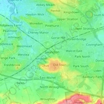
Naam: Topografische kaart Swindon, hoogte, reliëf.
Locatie: Swindon, England, SN1 1JZ, United Kingdom (51.52153 -1.82543 51.60153 -1.74543)
Gemiddelde hoogte: 108 m
Minimale hoogte: 83 m
Maximale hoogte: 181 m
Andere topografische kaarten
Klik op een kaart om zijn topografie, zijn hoogte en zijn reliëf te bekijken.