Geolokaliseren
👉 Easily get elevation data in JSON, GeoTIFF and KML formats using Elevation API
Bedankt voor het steunen van deze site ❤️
Doe een donatie

Rust jezelf uit voor je volgende avontuur:

Als Amazon-partner verdient deze site een commissie op in aanmerking komende aankopen, zonder extra kosten voor jou.

Topografische kaart Portsmouth

Klik op de kaart om de hoogte weer te geven.

Portsmouth

By road, Portsmouth lies 73.5 miles (118.3 km) from Central London, 49.5 miles (79.7 km) west of Brighton, and 22.3 miles (35.9 km) east of Southampton. Portsmouth is situated primarily on Portsea Island and is the United Kingdom's only island city, although parts of it have expanded onto the mainland. Gosport forms a borough in its own right immediately to the west. The island is separated from the mainland by Portsbridge Creek which is crossed by three road bridges (the M275 motorway, the A3 road, and the A2030 road), a railway bridge, and two footbridges. Portsea Island, which forms part of the Hampshire Basin, is low-lying: the majority of its surface area on the island is less than 3 metres (9.8 ft) above sea level. The highest natural elevation on Portsea Island is the road junction Kingston Cross, at 21 feet (6.4 m) above ordinary spring tide.

👉 Easily get elevation data in JSON, GeoTIFF and KML formats using Elevation API
Bedankt voor het steunen van deze site ❤️
Doe een donatie

Rust jezelf uit voor je volgende avontuur:

Als Amazon-partner verdient deze site een commissie op in aanmerking komende aankopen, zonder extra kosten voor jou.

Over deze kaart

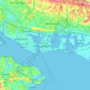
Naam: Topografische kaart Portsmouth, hoogte, reliëf.

Locatie: Portsmouth, Hampshire, South East England, England, PO1 5QH, United Kingdom (50.64368 -1.23561 50.96368 -0.91561)

Gemiddelde hoogte: 28 m

Minimale hoogte: -5 m

Maximale hoogte: 236 m

Andere topografische kaarten

Klik op een kaart om zijn topografie, zijn hoogte en zijn reliëf te bekijken.

Portsmouth

United Kingdom > England > Hampshire > Portsmouth

Gemiddelde hoogte: 9 m

Rust jezelf uit voor je volgende avontuur:

🧭Navigatie Tools - Handige hulpmiddelen voor routeplanning
🛰️Garmin Outdoor GPS - Betrouwbare Garmin GPS-apparaten voor wandelaars
👖Wandelbroeken - Sneldrogende en slijtvaste broeken voor outdoor
🎒Heuptasjes - Houd je smartphone en kaart binnen handbereik
📡Satelliet Communicators - Blijf bereikbaar in afgelegen gebieden

Als Amazon-partner verdient deze site een commissie op in aanmerking komende aankopen, zonder extra kosten voor jou.