Geolokaliseren

Topografische kaart Wirral

Klik op de kaart om de hoogte weer te geven.

Over deze kaart

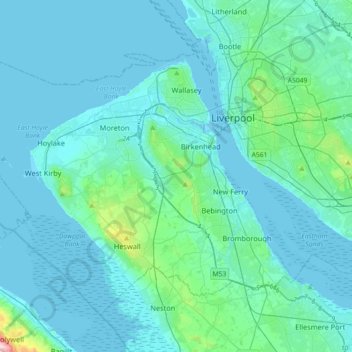
Naam: Topografische kaart Wirral, hoogte, reliëf.

Locatie: Wirral, Liverpool City Region, England, United Kingdom (53.28636 -3.26376 53.44948 -2.90317)

Gemiddelde hoogte: 21 m

Minimale hoogte: -2 m

Maximale hoogte: 245 m

Andere topografische kaarten

Klik op een kaart om zijn topografie, zijn hoogte en zijn reliëf te bekijken.

London

United Kingdom > England > London

Gemiddelde hoogte: 42 m

Leeds

United Kingdom > England

Lying in the eastern foothills of the Pennines, there is a significant variation in elevation within the city's built-up area. The district ranges from 1,115 feet (340 m) in the far west on the slopes of Ilkley Moor to about 33 feet (10 m) where the rivers Aire and Wharfe cross the eastern boundary. Land rises…

Gemiddelde hoogte: 94 m

Wembley

United Kingdom > England > Wembley

Gemiddelde hoogte: 44 m

Allendale Town

United Kingdom > England > Northumberland

Gemiddelde hoogte: 293 m

Queensbury

United Kingdom > England > Bradford

Gemiddelde hoogte: 284 m

York

United Kingdom > England > York

Gemiddelde hoogte: 21 m

Tyne and Wear

United Kingdom > England

Gemiddelde hoogte: 144 m

Brighton

United Kingdom > England > Brighton and Hove

Gemiddelde hoogte: 64 m

West Bromwich

United Kingdom > England > Sandwell

The town's football club is West Bromwich Albion. The club was founded in 1878 and in 1888 it became one of the 12 founder members of the Football League. It won the league championship in 1920 and has won the FA Cup five times, most recently in 1968, and won the League Cup in 1966. Albion were based in and…

Gemiddelde hoogte: 149 m

Bournville

United Kingdom > England > Birmingham

Gemiddelde hoogte: 148 m

Huddersfield

United Kingdom > England > Kirklees

Gemiddelde hoogte: 145 m

Macclesfield

United Kingdom > England > Macclesfield

Gemiddelde hoogte: 189 m

Gateshead

United Kingdom > England > Tyne and Wear > Gateshead

One of the most distinguishing features of Gateshead is its topography. The land rises 230 feet (70 m) from Gateshead Quays to the town centre and continues rising to a height of 525 feet (160 m) at Queen Elizabeth Hospital in Sheriff Hill. This is in contrast to the flat and low lying Team Valley located on…

Gemiddelde hoogte: 62 m

Banbury

United Kingdom > England > Cherwell > Banbury

Gemiddelde hoogte: 119 m

Cambridge

United Kingdom > England > Cambridge

The city, like most of the UK, has a maritime climate highly influenced by the Gulf Stream. Located in the driest region of Britain, Cambridge's rainfall averages around 570 mm (22.44 in) per year, around half the national average, with some years occasionally falling into the semi-arid (under 500 mm (19.69…

Gemiddelde hoogte: 18 m

Derby

United Kingdom > England > Derbyshire

Gemiddelde hoogte: 97 m

Littleborough

United Kingdom > England

In the late 18th century, the low-altitude Summit Gap between Littleborough and Walsden was approved as the best route over the Pennines for the Rochdale Canal and the Manchester to Leeds railway; Hollingworth Lake was built at Littleborough's south side as a feeder reservoir to regulate the waters of the…

Gemiddelde hoogte: 266 m

Reading

United Kingdom > England > Reading

Mary Russell Mitford lived in Reading for a number of years and then spent the rest of her life just outside the town at Three Mile Cross and Swallowfield. The fictional Belford Regis of her eponymous novel, first published in 1835, is largely based on Reading. Described with topographical accuracy, it is…

Gemiddelde hoogte: 56 m

Norwich

United Kingdom > England > Norfolk > Norwich

Gemiddelde hoogte: 29 m

Swindon

United Kingdom > England > Swindon

Swindon has an oceanic climate (Cfb in the Köppen climate classification), like the vast majority of the British Isles, with cool winters and warm summers. The nearest official weather station is RAF Lyneham, about 10 miles (16 km) west southwest of Swindon town centre. The weather station's elevation is 145…

Gemiddelde hoogte: 108 m

Bonchurch

United Kingdom > England > Isle of Wight > Ventnor

Gemiddelde hoogte: 58 m

Over Stratton

United Kingdom > England > Somerset

Gemiddelde hoogte: 42 m

Camber Sands

United Kingdom > England > East Sussex > Rother > Camber

Gemiddelde hoogte: 2 m

Northala Fields

United Kingdom > England > London > Northolt

Gemiddelde hoogte: 36 m

Sowerby Bridge

United Kingdom > England > Calderdale

Gemiddelde hoogte: 200 m

St Albans

United Kingdom > England > Hertfordshire > St Albans

St Albans was an ancient borough created following the dissolution of the monastery in 1539. It consisted of the ancient parish of St Albans (also known as the Abbey parish) and parts of St Michael and St Peter. The municipal corporation was reformed by the Municipal Corporations Act 1835 and the boundary was…

Gemiddelde hoogte: 100 m

Peterborough

United Kingdom > England > Cambridgeshire

The local topography is flat, and in some places, the land lies below sea level, for example in parts of the Fens to the east and to the south of Peterborough. Human settlement in the area began before the Bronze Age, as can be seen at the Flag Fen archaeological site to the east of the current city centre,…

Gemiddelde hoogte: 17 m

Roundway

United Kingdom > England > Wiltshire > Devizes

Gemiddelde hoogte: 146 m

Baxenden

United Kingdom > England > Lancashire > Hyndburn

Gemiddelde hoogte: 265 m

Downderry

United Kingdom > England > Cornwall

Gemiddelde hoogte: 49 m

Carbis Bay

United Kingdom > England > Cornwall > St. Ives

Gemiddelde hoogte: 55 m

Gleadless Common

United Kingdom > England > Sheffield

Gemiddelde hoogte: 177 m

Twickenham

United Kingdom > England > Greater London

Gemiddelde hoogte: 18 m

Lords Wood

United Kingdom > England > Medway

Gemiddelde hoogte: 134 m

Norland Town

United Kingdom > England > Calderdale > Norland

Gemiddelde hoogte: 172 m

Oare Creek

United Kingdom > England > Kent > Borough of Swale > Faversham > Oare

Gemiddelde hoogte: 6 m

Repps

United Kingdom > England > Norfolk > Great Yarmouth > Bastwick

Gemiddelde hoogte: 5 m

Toft Hill

United Kingdom > England > County Durham

Gemiddelde hoogte: 160 m

Oakworth

United Kingdom > England > Bradford

Gemiddelde hoogte: 226 m

Glaramara

United Kingdom > England > Cumberland

Gemiddelde hoogte: 478 m

Trawden

United Kingdom > England > Lancashire > Borough of Pendle

Gemiddelde hoogte: 243 m

Clevedon

United Kingdom > England > Clevedon

Gemiddelde hoogte: 10 m

Harpenden

United Kingdom > England > Harpenden

Gemiddelde hoogte: 120 m

Calne

United Kingdom > England > Calne

Gemiddelde hoogte: 103 m

Worksop

United Kingdom > England > Nottinghamshire > Bassetlaw

Gemiddelde hoogte: 56 m

Biggin Hill

United Kingdom > England > London

Gemiddelde hoogte: 171 m

Clitheroe

United Kingdom > England > Ribble Valley > Clitheroe

Gemiddelde hoogte: 125 m

Wilmslow

United Kingdom > England > Cheshire East

Gemiddelde hoogte: 84 m

Chesham

United Kingdom > England > Buckinghamshire

Gemiddelde hoogte: 147 m

Whitchurch

United Kingdom > England > Shropshire

Gemiddelde hoogte: 100 m

Glossop

United Kingdom > England > Derbyshire > High Peak

Gemiddelde hoogte: 284 m

Burwell

United Kingdom > England > Burwell

Gemiddelde hoogte: 12 m

Royston

United Kingdom > England > North Hertfordshire > Royston

Gemiddelde hoogte: 78 m

Kenilworth

United Kingdom > England > Kenilworth

Gemiddelde hoogte: 89 m

Newquay

United Kingdom > England > Newquay

Gemiddelde hoogte: 28 m

Leicester

United Kingdom > England > City of Leicester

Gemiddelde hoogte: 109 m

Plymouth

United Kingdom > England > Devon > Plymouth

The River Plym, which flows off Dartmoor to the north-east, forms a smaller estuary to the east of the city called Cattewater. Plymouth Sound is protected from the sea by the Plymouth Breakwater, in use since 1814. In the Sound is Drake's Island which is seen from Plymouth Hoe, a flat public area on top of…

Gemiddelde hoogte: 81 m

Durham

United Kingdom > England > County Durham

Gemiddelde hoogte: 119 m

Rawmarsh

United Kingdom > England

Gemiddelde hoogte: 64 m

Wimbledon

United Kingdom > England > Greater London

Gemiddelde hoogte: 26 m

Heywood

United Kingdom > England

Gemiddelde hoogte: 146 m

Thames Ditton

United Kingdom > England > Surrey > Elmbridge

Gemiddelde hoogte: 17 m

Walthamstow

United Kingdom > England

Gemiddelde hoogte: 21 m

Cambridge

United Kingdom > England > Cambridgeshire

The city, like most of the UK, has a maritime climate highly influenced by the Gulf Stream. Located in the driest region of Britain, Cambridge's rainfall averages around 570 mm (22.44 in) per year, around half the national average, The driest recent year was in 2011 with 380.4 mm (14.98 in) of rain at the…

Gemiddelde hoogte: 33 m

Liphook

United Kingdom > England > Hampshire > East Hampshire

In Samuel Lewis's 1831 Topographical Dictionary of England, he referred to Liphook as a hamlet in the parish of Bramshott.

Gemiddelde hoogte: 121 m

Yeovil

United Kingdom > England > Yeovil

Gemiddelde hoogte: 58 m

Shifnal

United Kingdom > England > Shifnal

Gemiddelde hoogte: 108 m

Stourbridge

United Kingdom > England > Dudley

Gemiddelde hoogte: 113 m

Portsmouth

United Kingdom > England > Hampshire > Portsmouth

By road, Portsmouth lies 73.5 miles (118.3 km) from Central London, 49.5 miles (79.7 km) west of Brighton, and 22.3 miles (35.9 km) east of Southampton. Portsmouth is situated primarily on Portsea Island and is the United Kingdom's only island city, although parts of it have expanded onto the mainland. Gosport…

Gemiddelde hoogte: 28 m

Keswick

United Kingdom > England > Keswick

Gemiddelde hoogte: 223 m

Altrincham

United Kingdom > England > Trafford

Gemiddelde hoogte: 37 m

Isleworth

United Kingdom > England > Greater London

If deemed to still include Osterley, elevations range from 27 m (89 ft) in the northwest to 4.9 m (16 ft) by the Thames OD. The boundaries are longstanding, subject to twentieth-century western and southern circonscriptions: Isleworth is east of the town of Hounslow which has more retail and offices, in the…

Gemiddelde hoogte: 19 m

Ashford

United Kingdom > England > Kent

Gemiddelde hoogte: 49 m

Pelsall

United Kingdom > England > Walsall

Gemiddelde hoogte: 143 m

Leigh

United Kingdom > England

Gemiddelde hoogte: 34 m

Bushy Park

United Kingdom > England > London

Gemiddelde hoogte: 12 m

Ruislip Lido

United Kingdom > England > London

Gemiddelde hoogte: 61 m

Coundon

United Kingdom > England > County Durham

Gemiddelde hoogte: 142 m

Monkwood

United Kingdom > England > Hampshire > East Hampshire

Gemiddelde hoogte: 168 m

Heage

United Kingdom > England > Derbyshire > Amber Valley

Gemiddelde hoogte: 118 m

Knottingley

United Kingdom > England > Wakefield

Gemiddelde hoogte: 21 m

Hoyland

United Kingdom > England

Gemiddelde hoogte: 96 m

Rust jezelf uit voor je volgende avontuur:

🐕Hondenharnassen - Neem je hond mee op je topografische avonturen
🛰️Garmin Outdoor GPS - Betrouwbare Garmin GPS-apparaten voor wandelaars
🦯Nordic Walking Stokken - Specifieke stokken voor sportief wandelen
Trekking Tenten - Lichte en stevige tenten voor wandelvakanties
👖Wandelbroeken - Sneldrogende en slijtvaste broeken voor outdoor

Als Amazon-partner verdient deze site een commissie op in aanmerking komende aankopen, zonder extra kosten voor jou.