
Topografische kaart St Albans
Klik op de kaart om de hoogte weer te geven.
St Albans
St Albans was an ancient borough created following the dissolution of the monastery in 1539. It consisted of the ancient parish of St Albans (also known as the Abbey parish) and parts of St Michael and St Peter. The municipal corporation was reformed by the Municipal Corporations Act 1835 and the boundary was adjusted to additionally include part of the parish of St Stephen. In 1887 the borough gained city status, following the elevation of St Albans Abbey to cathedral, and the boundary was adjusted to include part of the parish of Sandridge.
Over deze kaart
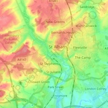
Naam: Topografische kaart St Albans, hoogte, reliëf.
Gemiddelde hoogte: 100 m
Minimale hoogte: 64 m
Maximale hoogte: 141 m
Andere topografische kaarten
Klik op een kaart om zijn topografie, zijn hoogte en zijn reliëf te bekijken.
Blackmore End
United Kingdom > England > Hertfordshire > St Albans > Wheathampstead
Gemiddelde hoogte: 114 m
Lower Gustard Wood
United Kingdom > England > Hertfordshire > St Albans > Wheathampstead
Gemiddelde hoogte: 112 m
Tyttenhanger
United Kingdom > England > Hertfordshire > St Albans > Colney Heath
Gemiddelde hoogte: 83 m
Napsbury Park
United Kingdom > England > Hertfordshire > St Albans > London Colney
Gemiddelde hoogte: 78 m
Harpenden
United Kingdom > England > Hertfordshire > St Albans > Hatching Green
Gemiddelde hoogte: 119 m