
Topografische kaart Bihar
Interactieve kaart
Klik op de kaart om de hoogte weer te geven.
Over deze kaart
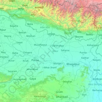
Naam: Topografische kaart Bihar, hoogte, reliëf.
Locatie: Bihar, India (24.28572 83.32126 27.52164 88.29823)
Gemiddelde hoogte: 606 m
Minimale hoogte: 11 m
Maximale hoogte: 8.419 m
Bihar covers a total area of 94,163 km2 (36,357 sq mi), with an average elevation above sea level of 173 feet (53 m). It is land locked by Nepal in the north, Jharkhand in the south West Bengal in the east and Uttar Pradesh to the west. It has three parts on the basis of physical and structural conditions: the Southern Plateau, the Shivalik Region, and Bihar's Gangetic Plain. Furthermore, the vast stretch of fertile Bihar Plain is divided by the Ganges River into two unequal parts – North Bihar and South Bihar. The Ganges flows west–east and, along with its tributaries, regularly floods parts of the Bihar plain. The main northern tributaries are the Gandak and Koshi, which originate in the Nepalese Himalayas, and the Bagmati, which originates in the Kathmandu Valley. Other tributaries are the Son, Budhi Gandak, Chandan, Orhani and Phalgu. Bihar has some small hills, such as the Rajgir hills in center, Kaimur Range in south-west and Shivalik Range in North. Bihar has notified forest area of 6,764.14 km2, which is 7.1 per cent of its geographical area. The sub-Himalayan foothills of Shivalik ranges, primary Someshwar and Dun mountain, in West Champaran district are clad in a belt of moist deciduous forest. As well as trees, this consists of scrub, grass and reeds.
Andere topografische kaarten
Klik op een kaart om zijn topografie, zijn hoogte en zijn reliëf te bekijken.
Taleni
India > Madhya Pradesh > Polayakala Tahsil
Taleni, Polayakala Tahsil, Shajapur District, Madhya Pradesh, 465113, India
Gemiddelde hoogte: 462 m
Gaduka
India > Gujarat > Jamnagar Taluka
Gaduka, Jamnagar Taluka, Jamnagar District, Gujarat, India
Gemiddelde hoogte: 17 m
Ward 11
Ward 11, Chandigarh, Chandigarh District, Chandigarh, India
Gemiddelde hoogte: 328 m
Kanpur Dehat District
Kanpur Dehat District, Uttar Pradesh, India
Gemiddelde hoogte: 132 m
Bengaluru
India > Karnataka > Bangalore North
Bengaluru, Bangalore North, Bengaluru Urban, Karnataka, India
Gemiddelde hoogte: 886 m
Car Nicobar
India > Andaman and Nicobar Islands
Car Nicobar, Nicobar District, Andaman and Nicobar Islands, India
Gemiddelde hoogte: 11 m
Coronation Park
India > Delhi > Model Town Tehsil
Coronation Park, Model Town Tehsil, North Delhi District, Delhi, India
Gemiddelde hoogte: 209 m
Bangalore South
Bangalore South, Bengaluru Urban, Karnataka, India
Gemiddelde hoogte: 847 m
Eastern West Khasi Hills District
Eastern West Khasi Hills District, Meghalaya, 793120, India
Gemiddelde hoogte: 1.176 m
Amber
India > Rajasthan > Amber Tehsil > Jaipur Municipal Corporation
Amber, Jaipur Municipal Corporation, Amber Tehsil, Jaipur District, Rajasthan, 303101, India
Gemiddelde hoogte: 468 m
Ankleshwar
India > Gujarat > Ankleshwar Taluka
Ankleshwar, Ankleshwar Taluka, Bharuch District, Gujarat, India
Gemiddelde hoogte: 17 m
Sundargarh
India > Odisha > Sundargarh Town
Sundargarh, Sundargarh Town, Sundargarh District, Odisha, 770001, India
Gemiddelde hoogte: 243 m
Khasi Hills
India > Meghalaya > Mawshynrut
Khasi Hills, Mawshynrut, West Khasi Hills District, Meghalaya, India
Gemiddelde hoogte: 349 m
Sullurpeta
India > Andhra Pradesh > Sullurpeta
Sullurpeta, Tirupati District, Andhra Pradesh, 524121, India
Gemiddelde hoogte: 4 m
Vinchhiya
India > Gujarat > Vinchhiya Taluka
Vinchhiya, Vinchhiya Taluka, Rajkot District, Gujarat, 360050, India
Gemiddelde hoogte: 173 m
South Lhonak Glacier
India > Sikkim > Chungthang
South Lhonak Glacier, Chungthang, Mangan District, Sikkim, India
Gemiddelde hoogte: 5.830 m
New Town
New Town, North 24 Parganas District, West Bengal, 700161, India
Gemiddelde hoogte: 5 m
Khutala
India > Maharashtra > Chimur Taluka
Khutala, Chimur Taluka, Chandrapur District, Maharashtra, 442904, India
Gemiddelde hoogte: 225 m
Ward 91
India > Tamil Nadu > Ambattur
Ward 91, Zone 7 Ambattur, Ambattur, Thiruvallur District, Tamil Nadu, 600037, India
Gemiddelde hoogte: 15 m
Nicobar Islands
India > Andaman and Nicobar Islands > Great Nicobar
Nicobar Islands, Great Nicobar, Nicobar, Andaman and Nicobar Islands, India
Gemiddelde hoogte: 2 m
Pallavaram
Pallavaram, Chengalpattu District, Tamil Nadu, India
Gemiddelde hoogte: 21 m
Dantiwada
India > Gujarat > Dantiwada Taluka
Dantiwada, Dantiwada Taluka, Banas Kantha District, Gujarat, 385505, India
Gemiddelde hoogte: 168 m
Sriperumbudur
Sriperumbudur, Kanchipuram District, Tamil Nadu, India
Gemiddelde hoogte: 48 m
Ward 92
India > Tamil Nadu > Ambattur
Ward 92, Zone 7 Ambattur, Ambattur, Thiruvallur District, Tamil Nadu, India
Gemiddelde hoogte: 15 m
Hassan
India > Karnataka > Hasana taluk
Hassan, Hasana taluk, Hassan district, Karnataka, 573201, India
Gemiddelde hoogte: 949 m
Leh
India > Ladakh > Leh Tehsil
Leh, Leh Tehsil, Leh district, Ladakh, India
Gemiddelde hoogte: 3.653 m
Bengaluru
India > Karnataka > Bangalore North > Bengaluru
Bengaluru, Bangalore North, Bangalore Urban, Karnataka, 560001, India
Gemiddelde hoogte: 879 m
Vasana
India > Karnataka > Harihara taluku > Vasana
Vasana, Harihara taluku, Davanagere District, Karnataka, 581119, India
Gemiddelde hoogte: 543 m
Ward 37
India > Odisha > Bhubaneswar (M.Corp.) > Bhubaneswar Municipal Corporation
Ward 37, South West Zone, Bhubaneswar Municipal Corporation, Bhubaneswar (M.Corp.), Khordha, Odisha, 751001, India
Gemiddelde hoogte: 51 m