Topografische kaart Bengaluru
Interactieve kaart
Klik op de kaart om de hoogte weer te geven.
Over deze kaart
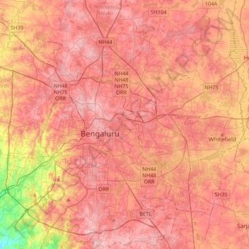
Naam: Topografische kaart Bengaluru, hoogte, reliëf.
Locatie: Bengaluru, Bangalore North, Bengaluru Urban, Karnataka, India (12.83363 77.46005 13.14266 77.78436)
Gemiddelde hoogte: 886 m
Minimale hoogte: 731 m
Maximale hoogte: 965 m
Bangalore (/ˈbæŋɡəlɔːr, ˌbæŋɡəˈlɔːr/ BANG-gə-lor, -LOR), officially Bengaluru (Kannada pronunciation: [ˈbeŋgɐɭuːɾu] ), is the capital and largest city of the southern Indian state of Karnataka. It has a population of more than 8 million and a metropolitan population of around 15 million, making it India's third most populous city and fourth most populous urban agglomeration. It is the most populous city and largest urban agglomeration in South India, and is the 27th largest city in the world. Located on the Deccan Plateau, at a height of over 900 m (3,000 ft) above sea level, Bangalore has a pleasant climate throughout the year, with its parks and green spaces earning it the reputation of India's "Garden City". Its elevation is the highest of India's major cities.
Andere topografische kaarten
Klik op een kaart om zijn topografie, zijn hoogte en zijn reliëf te bekijken.
Bengaluru
India > Karnataka > Bangalore North > Bengaluru
Bengaluru, Bangalore North, Bangalore Urban, Karnataka, 560001, India
Gemiddelde hoogte: 879 m