
Topografische kaart Sitapur
Interactieve kaart
Klik op de kaart om de hoogte weer te geven.
Over deze kaart
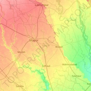
Naam: Topografische kaart Sitapur, hoogte, reliëf.
Locatie: Sitapur, Uttar Pradesh, India (27.10146 80.29944 27.90762 81.41530)
Gemiddelde hoogte: 131 m
Minimale hoogte: 108 m
Maximale hoogte: 158 m
Sitapur is located at 27.57°N 80.68°E. It test has an average elevation of 138 meters (452 feet). It is located in the Gangetic Plain, with elevations ranging from 150 m above sea level in the north-west to 100 m in the south-east. It is intersected by numerous streams and ravines and contains many shallow ponds and natural reservoirs, which overflow during the rainy seasons, but become dry, in some places, in the hot season. Except in the eastern portion, which lies in the doabs between the Kewani and the Chauka, and the Ghaghra and the Chauka rivers, the soil is semi arid. Even this moist tract is interspersed with patches of land covered with saline efflorescence called reh.
Andere topografische kaarten
Klik op een kaart om zijn topografie, zijn hoogte en zijn reliëf te bekijken.
Kanpur Dehat District
Kanpur Dehat District, Uttar Pradesh, India
Gemiddelde hoogte: 132 m
Ganges
India > Uttar Pradesh > Ghazipur
Ganges, Ghazipur, Uttar Pradesh, 233001, India
Gemiddelde hoogte: 1.626 m
Nizamabad
Nizamabad, Azamgarh, Uttar Pradesh, 276305, India
Gemiddelde hoogte: 81 m
Beel Akbarpur
India > Uttar Pradesh > Beel Akbarpur
Beel Akbarpur, Ghaziabad, Uttar Pradesh, 201314, India
Gemiddelde hoogte: 208 m