
Topografische kaart Macon County
Interactieve kaart
Klik op de kaart om de hoogte weer te geven.
Over deze kaart
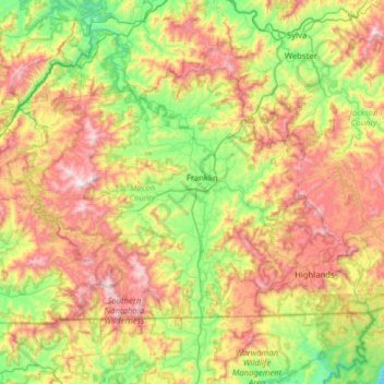
Naam: Topografische kaart Macon County, hoogte, reliëf.
Locatie: Macon County, North Carolina, United States (34.99331 -83.73818 35.33098 -83.10840)
Gemiddelde hoogte: 904 m
Minimale hoogte: 418 m
Maximale hoogte: 1.650 m
Cullasaja Falls is a waterfall in Southwestern North Carolina east of Franklin. The waterfall is located on the Cullasaja River in the Nantahala National Forest and is part of the Mountain Waters Scenic Byway. Cullasaja comes from a Cherokee word meaning "honey locust place." The falls is the last major waterfall on the Cullasaja River. The falls is a long cascade over the course of 0.2 miles (300 m). The height of the falls is given as 200 ft (61 m) in Kevin Adams' book, North Carolina Waterfalls and 250 ft (77 m) by NCWaterfalls.com. Google Earth gives a height (based on the elevation of the water at the top of the falls and the elevation of the plunge pool at the bottom of the falls) of 137 ft (42 m).
Andere topografische kaarten
Klik op een kaart om zijn topografie, zijn hoogte en zijn reliëf te bekijken.
Asheville
United States > North Carolina > Buncombe County
Asheville, Buncombe County, North Carolina, United States
Gemiddelde hoogte: 727 m
Boone
United States > North Carolina > Watauga County
Boone, Watauga County, North Carolina, United States
Gemiddelde hoogte: 1.068 m
Charlotte
United States > North Carolina > Mecklenburg County
Charlotte, Mecklenburg County, North Carolina, United States
Gemiddelde hoogte: 207 m
Wilmington
United States > North Carolina > New Hanover County
Wilmington, New Hanover County, North Carolina, United States
Gemiddelde hoogte: 7 m
Maggie Valley
United States > North Carolina > Haywood County
Maggie Valley, Haywood County, North Carolina, United States
Gemiddelde hoogte: 1.247 m
Banner Elk
United States > North Carolina > Avery County
Banner Elk, Avery County, North Carolina, United States
Gemiddelde hoogte: 1.165 m
Bryson City
United States > North Carolina > Swain County
Bryson City, Swain County, North Carolina, United States
Gemiddelde hoogte: 592 m
Altapass
United States > North Carolina > Mitchell County
Altapass, Mitchell County, North Carolina, 28777, United States
Gemiddelde hoogte: 854 m
Waynesville
United States > North Carolina > Haywood County
Waynesville, Haywood County, North Carolina, 28786, United States
Gemiddelde hoogte: 921 m
Blowing Rock
United States > North Carolina > Watauga County
Blowing Rock, Watauga County, North Carolina, 28605, United States
Gemiddelde hoogte: 1.032 m
Union County
United States > North Carolina
Union County, North Carolina, United States
Gemiddelde hoogte: 172 m
Hendersonville
United States > North Carolina > Henderson County
Hendersonville, Henderson County, North Carolina, 28738, United States
Gemiddelde hoogte: 669 m
Appalachian Mountains
United States > North Carolina > Yancey County
Appalachian Mountains, Yancey County, North Carolina, United States
Gemiddelde hoogte: 1.463 m
Lake Wheeler
United States > North Carolina > Wake County
Lake Wheeler, Wake County, North Carolina, United States
Gemiddelde hoogte: 104 m
Mooresville
United States > North Carolina > Iredell County
Mooresville, Iredell County, North Carolina, 28115, United States
Gemiddelde hoogte: 252 m
Rutherford County
United States > North Carolina
Rutherford County, North Carolina, United States
Gemiddelde hoogte: 345 m
Morganton
United States > North Carolina > Burke County
Morganton, Burke County, North Carolina, 28655, United States
Gemiddelde hoogte: 355 m
Oak Island
United States > North Carolina > Brunswick County > Oak Island
Oak Island, Brunswick County, North Carolina, 28465, United States
Gemiddelde hoogte: 4 m
Cary
United States > North Carolina > Wake County
Cary, Wake County, North Carolina, United States
Gemiddelde hoogte: 111 m
Henderson County
United States > North Carolina
Henderson County, North Carolina, United States
Gemiddelde hoogte: 703 m
Franklin
United States > North Carolina > Macon County
Franklin, Macon County, North Carolina, 28734, United States
Gemiddelde hoogte: 675 m
Wake Forest
United States > North Carolina > Wake County
Wake Forest, Wake County, North Carolina, United States
Gemiddelde hoogte: 105 m
Falls Lake
United States > North Carolina > Durham County
Falls Lake, Durham County, North Carolina, United States
Gemiddelde hoogte: 101 m
Corolla
United States > North Carolina > Currituck County
Corolla, Currituck County, North Carolina, 27927, United States
Gemiddelde hoogte: 0 m
Watauga County
United States > North Carolina
Watauga County, North Carolina, United States
Gemiddelde hoogte: 984 m
Black Mountain
United States > North Carolina > Buncombe County
Black Mountain, Buncombe County, North Carolina, 28711, United States
Gemiddelde hoogte: 784 m
New Bern
United States > North Carolina > Craven County
New Bern, Craven County, North Carolina, United States
Gemiddelde hoogte: 5 m
Greensboro
United States > North Carolina > Guilford County
Greensboro, Guilford County, North Carolina, United States
Gemiddelde hoogte: 242 m
West Jefferson
United States > North Carolina > Ashe County
West Jefferson, Ashe County, North Carolina, United States
Gemiddelde hoogte: 1.002 m
Statesville
United States > North Carolina > Iredell County
Statesville, Iredell County, North Carolina, 28688, United States
Gemiddelde hoogte: 269 m
Evergreen
United States > North Carolina > Columbus County
Evergreen, Columbus County, North Carolina, 28436, United States
Gemiddelde hoogte: 15 m
Weaverville
United States > North Carolina > Buncombe County
Weaverville, Buncombe County, North Carolina, United States
Gemiddelde hoogte: 679 m
Leland
United States > North Carolina > Brunswick County
Leland, Brunswick County, North Carolina, United States
Gemiddelde hoogte: 8 m
Raleigh
United States > North Carolina > Wake County
Raleigh, Wake County, North Carolina, United States
Gemiddelde hoogte: 103 m
Chapel Hill
United States > North Carolina > Orange County
Chapel Hill, Orange County, North Carolina, United States
Gemiddelde hoogte: 126 m
Avery County
United States > North Carolina
Avery County, North Carolina, United States
Gemiddelde hoogte: 1.006 m
Freeland
United States > North Carolina > Brunswick County
Freeland, Brunswick County, North Carolina, United States
Gemiddelde hoogte: 12 m
Alamance County
United States > North Carolina
Alamance County, North Carolina, United States
Gemiddelde hoogte: 194 m
High Point
United States > North Carolina > Guilford County
High Point, Guilford County, North Carolina, United States
Gemiddelde hoogte: 261 m
Winston-Salem
United States > North Carolina > Forsyth County
Winston-Salem, Forsyth County, North Carolina, United States
Gemiddelde hoogte: 263 m
Madison County
United States > North Carolina
Madison County, North Carolina, United States
Gemiddelde hoogte: 802 m
Pinehurst
United States > North Carolina > Moore County
Pinehurst, Moore County, North Carolina, 28374, United States
Gemiddelde hoogte: 138 m
Blue Ridge Parkway
United States > North Carolina > Watauga County
Blue Ridge Parkway, Watauga County, North Carolina, United States
Gemiddelde hoogte: 504 m
Cashiers
United States > North Carolina > Jackson County > Cashiers
Cashiers, Jackson County, North Carolina, United States
Gemiddelde hoogte: 1.085 m
Bat Cave
United States > North Carolina > Henderson County
Bat Cave, Henderson County, North Carolina, 28710, United States
Gemiddelde hoogte: 648 m
Wilkes County
United States > North Carolina
Wilkes County, North Carolina, United States
Gemiddelde hoogte: 513 m
Southport
United States > North Carolina > Brunswick County
Southport, Brunswick County, North Carolina, United States
Gemiddelde hoogte: 6 m
Craven County
United States > North Carolina
Craven County, North Carolina, United States
Gemiddelde hoogte: 8 m
Scuppernong
United States > North Carolina > Washington County
Scuppernong, Washington County, North Carolina, United States
Gemiddelde hoogte: 3 m
Beech Mountain
United States > North Carolina > Watauga County
Beech Mountain, Watauga County, North Carolina, United States
Gemiddelde hoogte: 1.267 m