
Topografische kaart Wilkes County
Interactieve kaart
Klik op de kaart om de hoogte weer te geven.
Over deze kaart
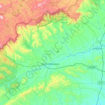
Naam: Topografische kaart Wilkes County, hoogte, reliëf.
Locatie: Wilkes County, North Carolina, United States (35.99484 -81.54549 36.44078 -80.86875)
Gemiddelde hoogte: 513 m
Minimale hoogte: 248 m
Maximale hoogte: 1.395 m
Wilkes County is located on the eastern slope of the Blue Ridge Mountains, a part of the Appalachian Mountains chain. The county's elevation ranges from 900 feet (375 meters) in the east to over 4,000 feet (1,219 meters) in the west. The Blue Ridge Mountains run from the southwest to the northeast, and dominate the county's western and northern horizons. Tomkins Knob, the highest point in the county, rises to 4,079 feet (1243 meters). The Blue Ridge Parkway runs along the crest of the Blue Ridge on the county's northern and western borders. The foothills and valleys of the Blue Ridge form most of the county's midsection, with some elevations exceeding 2,000 feet (610 meters). Stone Mountain State Park, located in the foothills of northern Wilkes County, is one of the most popular state parks in North Carolina, and is noted for its excellent rock climbing and trout fishing. The Brushy Mountains, an isolated spur of the Blue Ridge, form the county's southern border. Wilkes County's terrain gradually becomes more level and less hilly as one moves to the east; the far eastern section of the county lies within the Piedmont region of North Carolina. The largest river in Wilkes is the Yadkin River, which flows through the central part of the county. The county's three other major streams, all of which flow into the Yadkin, are the Reddies River, Roaring River, and Mulberry Creek. Following the devastating floods of 1916 and 1940, the US Army's Corps of Engineers constructed the W. Kerr Scott Dam and Reservoir on the Yadkin River four miles west of Wilkesboro. Opened in 1962, the dam created a lake with a shoreline of 56 miles. The lake is used for boating, swimming, fishing, and waterskiing; it is especially noted for its excellent bass fishing. The W. Kerr Scott lake is the largest body of water in Wilkes.
Andere topografische kaarten
Klik op een kaart om zijn topografie, zijn hoogte en zijn reliëf te bekijken.
Asheville
United States > North Carolina > Buncombe County
Asheville, Buncombe County, North Carolina, United States
Gemiddelde hoogte: 727 m
Boone
United States > North Carolina > Watauga County
Boone, Watauga County, North Carolina, United States
Gemiddelde hoogte: 1.068 m
Charlotte
United States > North Carolina > Mecklenburg County
Charlotte, Mecklenburg County, North Carolina, United States
Gemiddelde hoogte: 207 m
Wilmington
United States > North Carolina > New Hanover County
Wilmington, New Hanover County, North Carolina, United States
Gemiddelde hoogte: 7 m
Maggie Valley
United States > North Carolina > Haywood County
Maggie Valley, Haywood County, North Carolina, United States
Gemiddelde hoogte: 1.247 m
Banner Elk
United States > North Carolina > Avery County
Banner Elk, Avery County, North Carolina, United States
Gemiddelde hoogte: 1.165 m
Bryson City
United States > North Carolina > Swain County
Bryson City, Swain County, North Carolina, United States
Gemiddelde hoogte: 592 m
Hendersonville
United States > North Carolina > Henderson County
Hendersonville, Henderson County, North Carolina, 28738, United States
Gemiddelde hoogte: 669 m
Altapass
United States > North Carolina > Mitchell County
Altapass, Mitchell County, North Carolina, 28777, United States
Gemiddelde hoogte: 854 m
Waynesville
United States > North Carolina > Haywood County
Waynesville, Haywood County, North Carolina, 28786, United States
Gemiddelde hoogte: 921 m
Blowing Rock
United States > North Carolina > Watauga County
Blowing Rock, Watauga County, North Carolina, 28605, United States
Gemiddelde hoogte: 1.032 m
Union County
United States > North Carolina
Union County, North Carolina, United States
Gemiddelde hoogte: 172 m
Raleigh
United States > North Carolina > Wake County
Raleigh, Wake County, North Carolina, United States
Gemiddelde hoogte: 103 m
Appalachian Mountains
United States > North Carolina > Yancey County
Appalachian Mountains, Yancey County, North Carolina, United States
Gemiddelde hoogte: 1.463 m
Lake Wheeler
United States > North Carolina > Wake County
Lake Wheeler, Wake County, North Carolina, United States
Gemiddelde hoogte: 104 m
Mooresville
United States > North Carolina > Iredell County
Mooresville, Iredell County, North Carolina, 28115, United States
Gemiddelde hoogte: 252 m
Rutherford County
United States > North Carolina
Rutherford County, North Carolina, United States
Gemiddelde hoogte: 345 m
Morganton
United States > North Carolina > Burke County
Morganton, Burke County, North Carolina, 28655, United States
Gemiddelde hoogte: 355 m
Oak Island
United States > North Carolina > Brunswick County > Oak Island
Oak Island, Brunswick County, North Carolina, 28465, United States
Gemiddelde hoogte: 4 m
Cary
United States > North Carolina > Wake County
Cary, Wake County, North Carolina, United States
Gemiddelde hoogte: 111 m
Henderson County
United States > North Carolina
Henderson County, North Carolina, United States
Gemiddelde hoogte: 703 m
Franklin
United States > North Carolina > Macon County
Franklin, Macon County, North Carolina, 28734, United States
Gemiddelde hoogte: 675 m
Wake Forest
United States > North Carolina > Wake County
Wake Forest, Wake County, North Carolina, United States
Gemiddelde hoogte: 105 m
Falls Lake
United States > North Carolina > Durham County
Falls Lake, Durham County, North Carolina, United States
Gemiddelde hoogte: 101 m
Corolla
United States > North Carolina > Currituck County
Corolla, Currituck County, North Carolina, 27927, United States
Gemiddelde hoogte: 0 m
Watauga County
United States > North Carolina
Watauga County, North Carolina, United States
Gemiddelde hoogte: 984 m
Black Mountain
United States > North Carolina > Buncombe County
Black Mountain, Buncombe County, North Carolina, 28711, United States
Gemiddelde hoogte: 784 m
New Bern
United States > North Carolina > Craven County
New Bern, Craven County, North Carolina, United States
Gemiddelde hoogte: 5 m
Greensboro
United States > North Carolina > Guilford County
Greensboro, Guilford County, North Carolina, United States
Gemiddelde hoogte: 242 m
West Jefferson
United States > North Carolina > Ashe County
West Jefferson, Ashe County, North Carolina, United States
Gemiddelde hoogte: 1.002 m
Statesville
United States > North Carolina > Iredell County
Statesville, Iredell County, North Carolina, 28688, United States
Gemiddelde hoogte: 269 m
Evergreen
United States > North Carolina > Columbus County
Evergreen, Columbus County, North Carolina, 28436, United States
Gemiddelde hoogte: 15 m
Weaverville
United States > North Carolina > Buncombe County
Weaverville, Buncombe County, North Carolina, United States
Gemiddelde hoogte: 679 m
Leland
United States > North Carolina > Brunswick County
Leland, Brunswick County, North Carolina, United States
Gemiddelde hoogte: 8 m
Chapel Hill
United States > North Carolina > Orange County
Chapel Hill, Orange County, North Carolina, United States
Gemiddelde hoogte: 126 m
Avery County
United States > North Carolina
Avery County, North Carolina, United States
Gemiddelde hoogte: 1.006 m
Freeland
United States > North Carolina > Brunswick County
Freeland, Brunswick County, North Carolina, United States
Gemiddelde hoogte: 12 m
Alamance County
United States > North Carolina
Alamance County, North Carolina, United States
Gemiddelde hoogte: 194 m
High Point
United States > North Carolina > Guilford County
High Point, Guilford County, North Carolina, United States
Gemiddelde hoogte: 261 m
Winston-Salem
United States > North Carolina > Forsyth County
Winston-Salem, Forsyth County, North Carolina, United States
Gemiddelde hoogte: 263 m
Madison County
United States > North Carolina
Madison County, North Carolina, United States
Gemiddelde hoogte: 802 m
Pinehurst
United States > North Carolina > Moore County
Pinehurst, Moore County, North Carolina, 28374, United States
Gemiddelde hoogte: 138 m
Blue Ridge Parkway
United States > North Carolina > Watauga County
Blue Ridge Parkway, Watauga County, North Carolina, United States
Gemiddelde hoogte: 504 m
Cashiers
United States > North Carolina > Jackson County > Cashiers
Cashiers, Jackson County, North Carolina, United States
Gemiddelde hoogte: 1.085 m
Bat Cave
United States > North Carolina > Henderson County
Bat Cave, Henderson County, North Carolina, 28710, United States
Gemiddelde hoogte: 648 m
Southport
United States > North Carolina > Brunswick County
Southport, Brunswick County, North Carolina, United States
Gemiddelde hoogte: 6 m
Craven County
United States > North Carolina
Craven County, North Carolina, United States
Gemiddelde hoogte: 8 m
Scuppernong
United States > North Carolina > Washington County
Scuppernong, Washington County, North Carolina, United States
Gemiddelde hoogte: 3 m
Beech Mountain
United States > North Carolina > Watauga County
Beech Mountain, Watauga County, North Carolina, United States
Gemiddelde hoogte: 1.267 m
Durham
United States > North Carolina > Durham County
Durham, Durham County, North Carolina, United States
Gemiddelde hoogte: 117 m