
Topografische kaart West Jefferson
Interactieve kaart
Klik op de kaart om de hoogte weer te geven.
Over deze kaart
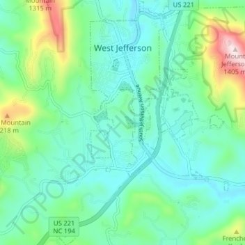
Naam: Topografische kaart West Jefferson, hoogte, reliëf.
Locatie: West Jefferson, Ashe County, North Carolina, United States (36.36200 -81.51109 36.41362 -81.46528)
Gemiddelde hoogte: 1.002 m
Minimale hoogte: 884 m
Maximale hoogte: 1.397 m
Andere topografische kaarten
Klik op een kaart om zijn topografie, zijn hoogte en zijn reliëf te bekijken.
Obids
United States > North Carolina > Ashe County
Obids, Ashe County, North Carolina, 28629, United States
Gemiddelde hoogte: 932 m
Mount Jefferson
United States > North Carolina > Ashe County
Mount Jefferson, Ashe County, North Carolina, 28694, United States
Gemiddelde hoogte: 1.078 m
South Fork New River
United States > North Carolina > Ashe County
South Fork New River, Ashe County, North Carolina, United States
Gemiddelde hoogte: 907 m
Baldwin
United States > North Carolina > Ashe County
Baldwin, Ashe County, North Carolina, United States
Gemiddelde hoogte: 1.027 m
Grassy Creek
United States > North Carolina > Ashe County
Grassy Creek, Ashe County, North Carolina, 24363, United States
Gemiddelde hoogte: 844 m
Glendale Springs
United States > North Carolina > Ashe County
Glendale Springs, Ashe County, North Carolina, 28629, United States
Gemiddelde hoogte: 891 m
Scottville
United States > North Carolina > Ashe County
Scottville, Ashe County, North Carolina, 28672, United States
Gemiddelde hoogte: 855 m
Lansing
United States > North Carolina > Ashe County
Lansing, Ashe County, North Carolina, 28643, United States
Gemiddelde hoogte: 917 m
Sutherland
United States > North Carolina > Ashe County
Sutherland, Ashe County, North Carolina, United States
Gemiddelde hoogte: 1.003 m
Three Top Mountain
United States > North Carolina > Ashe County
Three Top Mountain, Ashe County, North Carolina, United States
Gemiddelde hoogte: 1.235 m
Oval
United States > North Carolina > Ashe County
Oval, Ashe County, North Carolina, 28686, United States
Gemiddelde hoogte: 1.011 m
Warrensville
United States > North Carolina > Ashe County
Warrensville, Ashe County, North Carolina, 28693, United States
Gemiddelde hoogte: 931 m
Todd
United States > North Carolina > Ashe County
Todd, Ashe County, North Carolina, 28684, United States
Gemiddelde hoogte: 1.007 m
Transou
United States > North Carolina > Ashe County
Transou, Ashe County, North Carolina, 28644, United States
Gemiddelde hoogte: 906 m
Weavers Ford
United States > North Carolina > Ashe County
Weavers Ford, Ashe County, North Carolina, 28631, United States
Gemiddelde hoogte: 825 m
New River State Park
United States > North Carolina > Ashe County
New River State Park, Ashe County, North Carolina, United States
Gemiddelde hoogte: 896 m
Pond Mountain
United States > North Carolina > Ashe County
Pond Mountain, Ashe County, North Carolina, United States
Gemiddelde hoogte: 1.328 m
Creston
United States > North Carolina > Ashe County
Creston, Ashe County, North Carolina, 28615, United States
Gemiddelde hoogte: 984 m
Lansing
United States > North Carolina > Ashe County
Lansing, Ashe County, North Carolina, United States
Gemiddelde hoogte: 879 m
Fleetwood
United States > North Carolina > Ashe County
Fleetwood, Ashe County, North Carolina, 28626, United States
Gemiddelde hoogte: 936 m