
Topografische kaart Falls Lake
Interactieve kaart
Klik op de kaart om de hoogte weer te geven.
Over deze kaart
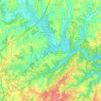
Naam: Topografische kaart Falls Lake, hoogte, reliëf.
Locatie: Falls Lake, Durham County, North Carolina, United States (35.92925 -78.80589 36.10287 -78.57298)
Gemiddelde hoogte: 101 m
Minimale hoogte: 70 m
Maximale hoogte: 167 m
Work on the dam that holds the lake began in 1978 and was completed in 1981. Prior to its construction flooding of the Neuse River caused extensive damage to public and private properties including roadways, railroads, industrial sites and farmlands. The U.S. Army Corps of Engineers constructed and manages the dam. Falls Dam (35°56′30″N 78°34′57″W / 35.94167°N 78.58250°W / 35.94167; -78.58250) is an earthen structure having a top elevation of 291.5 feet (88.8 m) and an overall length of 1,915 feet (584 m). The height above the streambed is 92.5 feet (28 m).
Andere topografische kaarten
Klik op een kaart om zijn topografie, zijn hoogte en zijn reliëf te bekijken.
Walden Pond
United States > North Carolina > Durham County > Durham
Walden Pond, Durham, Durham County, North Carolina, United States
Gemiddelde hoogte: 134 m
Durham
United States > North Carolina > Durham County
Durham, Durham County, North Carolina, United States
Gemiddelde hoogte: 117 m
Red Mountain
United States > North Carolina > Durham County
Red Mountain, Durham County, North Carolina, 27572, United States
Gemiddelde hoogte: 157 m
Rougemont
United States > North Carolina > Durham County
Rougemont, Durham County, North Carolina, United States
Gemiddelde hoogte: 174 m
Mill Grove
United States > North Carolina > Durham County > Durham
Mill Grove, Durham, Durham County, North Carolina, 27704, United States
Gemiddelde hoogte: 111 m
Trinity Park
United States > North Carolina > Durham County > Durham
Trinity Park, Durham, Durham County, North Carolina, United States
Gemiddelde hoogte: 116 m
Rougemont
United States > North Carolina > Durham County
Rougemont, Durham County, North Carolina, 27572, United States
Gemiddelde hoogte: 170 m
Sandy Creek Park
United States > North Carolina > Durham County > Durham
Sandy Creek Park, Durham, Durham County, North Carolina, 27707, United States
Gemiddelde hoogte: 92 m
Durham
United States > North Carolina > Durham County > Durham
Durham, Durham County, North Carolina, 27701, United States
Gemiddelde hoogte: 119 m
Redwood
United States > North Carolina > Durham County > Redwood
Redwood, Durham County, North Carolina, United States
Gemiddelde hoogte: 86 m
Eno River
United States > North Carolina > Durham County
Eno River, Durham County, North Carolina, 27705, United States
Gemiddelde hoogte: 134 m