
Topografische kaart Bleckley County
Interactieve kaart
Klik op de kaart om de hoogte weer te geven.
Over deze kaart
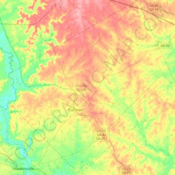
Naam: Topografische kaart Bleckley County, hoogte, reliëf.
Locatie: Bleckley County, Georgia, 31014, United States (32.27206 -83.49809 32.58441 -83.13899)
Gemiddelde hoogte: 104 m
Minimale hoogte: 58 m
Maximale hoogte: 154 m
Andere topografische kaarten
Klik op een kaart om zijn topografie, zijn hoogte en zijn reliëf te bekijken.
Atlanta
United States > Georgia > Fulton County
Atlanta, Fulton County, Georgia, United States
Gemiddelde hoogte: 284 m
Savannah
United States > Georgia > Chatham County
Savannah, Chatham County, Georgia, United States
Gemiddelde hoogte: 4 m
Athens
United States > Georgia > Athens
Athens, Athens-Clarke County, Georgia, 303341458, United States
Gemiddelde hoogte: 221 m
Blue Ridge
United States > Georgia > Fannin County
Blue Ridge, Fannin County, Georgia, United States
Gemiddelde hoogte: 535 m
Brunswick
United States > Georgia > Glynn County
Brunswick, Glynn County, Georgia, United States
Gemiddelde hoogte: 2 m
Augusta
United States > Georgia > Augusta
Augusta, Richmond County, Georgia, 30901, United States
Gemiddelde hoogte: 90 m
Tybee Island
United States > Georgia > Chatham County
Tybee Island, Chatham County, Georgia, 31328, United States
Gemiddelde hoogte: 1 m
Macon
United States > Georgia > Bibb County
Macon, Bibb County, Georgia, United States
Gemiddelde hoogte: 127 m
Columbus
United States > Georgia > Muscogee County
Columbus, Muscogee County, Georgia, United States
Gemiddelde hoogte: 130 m
Atlanta
United States > Georgia > Fulton County
Atlanta, Fulton County, Georgia, 30303, United States
Gemiddelde hoogte: 285 m
Ellijay
United States > Georgia > Gilmer County
Ellijay, Gilmer County, Georgia, 30540, United States
Gemiddelde hoogte: 424 m
Dahlonega
United States > Georgia > Lumpkin County
Dahlonega, Lumpkin County, Georgia, United States
Gemiddelde hoogte: 411 m
Vinings
United States > Georgia > Cobb County
Vinings, Cobb County, Georgia, 30339, United States
Gemiddelde hoogte: 281 m
Radio Springs
United States > Georgia > Floyd County
Radio Springs, Floyd County, Georgia, United States
Gemiddelde hoogte: 243 m
Helen
United States > Georgia > White County
Helen, White County, Georgia, 30545, United States
Gemiddelde hoogte: 488 m
Gwinnett County
Gwinnett County, Georgia, United States
Gemiddelde hoogte: 302 m
Hiawassee
United States > Georgia > Towns County
Hiawassee, Towns County, Georgia, United States
Gemiddelde hoogte: 620 m
Wilscot
United States > Georgia > Fannin County
Wilscot, Fannin County, Georgia, United States
Gemiddelde hoogte: 614 m
Blairsville
United States > Georgia > Union County
Blairsville, Union County, Georgia, United States
Gemiddelde hoogte: 587 m
Robins Air Force Base
United States > Georgia > Houston County
Robins Air Force Base, Houston County, Georgia, 31098, United States
Gemiddelde hoogte: 92 m
Gainesville
United States > Georgia > Hall County
Gainesville, Hall County, Georgia, 30501, United States
Gemiddelde hoogte: 346 m
Georgia International Horse Park
United States > Georgia > Rockdale County > Conyers
Georgia International Horse Park, Conyers, Rockdale County, Georgia, United States
Gemiddelde hoogte: 209 m
Alpharetta
United States > Georgia > Fulton County
Alpharetta, Fulton County, Georgia, United States
Gemiddelde hoogte: 324 m
Saint Simons Island
United States > Georgia > Glynn County
Saint Simons Island, Glynn County, Georgia, 31561, United States
Gemiddelde hoogte: 2 m
Skidaway Island
United States > Georgia > Chatham County
Skidaway Island, Chatham County, Georgia, 31411, United States
Gemiddelde hoogte: 3 m
Lumpkin
United States > Georgia > Stewart County
Lumpkin, Stewart County, Georgia, United States
Gemiddelde hoogte: 147 m
Canton
United States > Georgia > Cherokee County
Canton, Cherokee County, Georgia, United States
Gemiddelde hoogte: 320 m
Jointer Island
United States > Georgia > Glynn County > Brunswick
Jointer Island, Brunswick, Glynn County, Georgia, United States
Gemiddelde hoogte: 0 m
Heritage Acres
United States > Georgia > Bibb County > Macon
Heritage Acres, Macon, Bibb County, Georgia, 31211, United States
Gemiddelde hoogte: 119 m
Stone Mountain
United States > Georgia > DeKalb County
Stone Mountain, DeKalb County, Georgia, 30087, United States
Gemiddelde hoogte: 299 m
Woodstock
United States > Georgia > Cherokee County
Woodstock, Cherokee County, Georgia, United States
Gemiddelde hoogte: 296 m
Lake Oconee
United States > Georgia > Greene County > Lake Oconee
Lake Oconee, Greene County, Georgia, United States
Gemiddelde hoogte: 165 m
Mountain City
United States > Georgia > Rabun County
Mountain City, Rabun County, Georgia, 30562, United States
Gemiddelde hoogte: 747 m
Paulding County
Paulding County, Georgia, United States
Gemiddelde hoogte: 311 m
Kennesaw
United States > Georgia > Cobb County
Kennesaw, Cobb County, Georgia, 30144, United States
Gemiddelde hoogte: 317 m
Iron Mountain
United States > Georgia > Murray County
Iron Mountain, Murray County, Georgia, United States
Gemiddelde hoogte: 362 m
Fort Pulaski
United States > Georgia > Chatham County
Fort Pulaski, Fort Perimeter Trail, Chatham County, Georgia, 31328, United States
Gemiddelde hoogte: 1 m
Tugaloo
United States > Georgia > Habersham County > Tallulah Falls
Tugaloo, Tallulah Falls, Habersham County, Georgia, United States
Gemiddelde hoogte: 392 m
Elmodel
United States > Georgia > Baker County
Elmodel, Baker County, Georgia, United States
Gemiddelde hoogte: 51 m
Warner Robins
United States > Georgia > Houston County
Warner Robins, Houston County, Georgia, United States
Gemiddelde hoogte: 101 m