
Topografische kaart Radio Springs
Interactieve kaart
Klik op de kaart om de hoogte weer te geven.
Over deze kaart
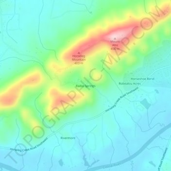
Naam: Topografische kaart Radio Springs, hoogte, reliëf.
Locatie: Radio Springs, Floyd County, Georgia, United States (34.20204 -85.26273 34.24204 -85.22273)
Gemiddelde hoogte: 243 m
Minimale hoogte: 174 m
Maximale hoogte: 442 m
Andere topografische kaarten
Klik op een kaart om zijn topografie, zijn hoogte en zijn reliëf te bekijken.
Lindale
United States > Georgia > Floyd County
Lindale, Floyd County, Georgia, 30147, United States
Gemiddelde hoogte: 229 m
Shannon
United States > Georgia > Floyd County
Shannon, Floyd County, Georgia, 30172, United States
Gemiddelde hoogte: 211 m
Rome
United States > Georgia > Floyd County
Rome, Floyd County, Georgia, United States
Gemiddelde hoogte: 211 m
Garden Lakes, City of Rome
United States > Georgia > Floyd County
Garden Lakes, City of Rome, Floyd County, Georgia, United States
Gemiddelde hoogte: 197 m
Cave Spring
United States > Georgia > Floyd County
Cave Spring, Floyd County, Georgia, United States
Gemiddelde hoogte: 237 m
Berryhill
United States > Georgia > Floyd County > Rome
Berryhill, Rome, Floyd County, Georgia, 30165, United States
Gemiddelde hoogte: 207 m
Cave Spring
United States > Georgia > Floyd County > Cave Spring
Cave Spring, Floyd County, Georgia, 30124, United States
Gemiddelde hoogte: 235 m