
Topografische kaart Blairsville
Interactieve kaart
Klik op de kaart om de hoogte weer te geven.
Over deze kaart
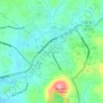
Naam: Topografische kaart Blairsville, hoogte, reliëf.
Locatie: Blairsville, Union County, Georgia, United States (34.86877 -83.96754 34.88341 -83.93990)
Gemiddelde hoogte: 587 m
Minimale hoogte: 542 m
Maximale hoogte: 726 m
Blairsville has a humid subtropical climate, yet due to its elevation of 1,883 feet (574 m), typically records far lower temperatures at night than what is encountered in much of the Southeastern U.S., and has slightly higher precipitation totals (56 inches or 1,420 millimetres annually) than most locations in the state; the average diurnal temperature variation exceeds 25 °F (14 °C) in each of the spring and autumn months. Snow usually occurs several times every year. The average annual snowfall is 4 inches. The monthly daily mean temperature ranges from 36.8 °F (2.7 °C) in January to 73.3 °F (22.9 °C) in July. There are 7.6 days of 90 °F (32 °C) highs and 4.6 days where the high fails to rise above freezing annually.
Andere topografische kaarten
Klik op een kaart om zijn topografie, zijn hoogte en zijn reliëf te bekijken.
Spile
United States > Georgia > Union County
Spile, Union County, Georgia, United States
Gemiddelde hoogte: 646 m
Suches
United States > Georgia > Union County
Suches, Union County, Georgia, United States
Gemiddelde hoogte: 871 m
Vogel State Park
United States > Georgia > Union County
Vogel State Park, Union County, Georgia, United States
Gemiddelde hoogte: 838 m
Hawk Mountain
United States > Georgia > Union County
Hawk Mountain, Union County, Georgia, United States
Gemiddelde hoogte: 912 m
Bethlehem
United States > Georgia > Union County
Bethlehem, Union County, Georgia, United States
Gemiddelde hoogte: 582 m
Fort Mountain
United States > Georgia > Union County
Fort Mountain, Union County, Georgia, United States
Gemiddelde hoogte: 679 m
Blue Rock
United States > Georgia > Union County
Blue Rock, Union County, Georgia, United States
Gemiddelde hoogte: 780 m