
Topografische kaart Vogel State Park
Interactieve kaart
Klik op de kaart om de hoogte weer te geven.
Over deze kaart
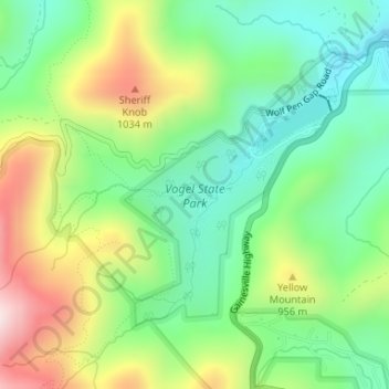
Naam: Topografische kaart Vogel State Park, hoogte, reliëf.
Locatie: Vogel State Park, Union County, Georgia, United States (34.75390 -83.93439 34.77208 -83.91583)
Gemiddelde hoogte: 838 m
Minimale hoogte: 659 m
Maximale hoogte: 1.140 m
Andere topografische kaarten
Klik op een kaart om zijn topografie, zijn hoogte en zijn reliëf te bekijken.
Blairsville
United States > Georgia > Union County
Blairsville, Union County, Georgia, United States
Gemiddelde hoogte: 587 m
Spile
United States > Georgia > Union County
Spile, Union County, Georgia, United States
Gemiddelde hoogte: 646 m
Suches
United States > Georgia > Union County
Suches, Union County, Georgia, United States
Gemiddelde hoogte: 871 m
Hawk Mountain
United States > Georgia > Union County
Hawk Mountain, Union County, Georgia, United States
Gemiddelde hoogte: 912 m
Bethlehem
United States > Georgia > Union County
Bethlehem, Union County, Georgia, United States
Gemiddelde hoogte: 582 m
Fort Mountain
United States > Georgia > Union County
Fort Mountain, Union County, Georgia, United States
Gemiddelde hoogte: 679 m
Blue Rock
United States > Georgia > Union County
Blue Rock, Union County, Georgia, United States
Gemiddelde hoogte: 780 m