
Topografische kaart Brunswick
Interactieve kaart
Klik op de kaart om de hoogte weer te geven.
Over deze kaart
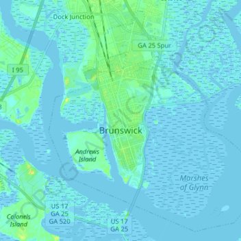
Naam: Topografische kaart Brunswick, hoogte, reliëf.
Locatie: Brunswick, Glynn County, Georgia, United States (31.10341 -81.53020 31.20499 -81.40078)
Gemiddelde hoogte: 2 m
Minimale hoogte: -3 m
Maximale hoogte: 22 m
The city is the lowest in the U.S. state of Georgia, with an elevation of only 10 to 14 feet (3.0 to 4.3 m) above sea level. According to the U.S. Census Bureau, Brunswick's land area is 32.4 square miles (83.8 km2). Its total area is 42.4 square miles (109.8 km2); 10.0 square miles (26.0 km2) of this is water.
Andere topografische kaarten
Klik op een kaart om zijn topografie, zijn hoogte en zijn reliëf te bekijken.
Saint Simons Island
United States > Georgia > Glynn County
Saint Simons Island, Glynn County, Georgia, 31561, United States
Gemiddelde hoogte: 2 m
Jointer Island
United States > Georgia > Glynn County > Brunswick
Jointer Island, Brunswick, Glynn County, Georgia, United States
Gemiddelde hoogte: 0 m
Fancy Bluff
United States > Georgia > Glynn County
Fancy Bluff, Glynn County, Georgia, United States
Gemiddelde hoogte: 3 m
Saint Simon Mills
United States > Georgia > Glynn County
Saint Simon Mills, Glynn County, Georgia, 31522, United States
Gemiddelde hoogte: 3 m
Saint Simons
United States > Georgia > Glynn County
Saint Simons, Glynn County, Georgia, 31522, United States
Gemiddelde hoogte: 2 m
Jekyll Island
United States > Georgia > Glynn County > Saint Simons
Jekyll Island, Saint Simons, Glynn County, Georgia, 31527, United States
Gemiddelde hoogte: 1 m
Gordon Oaks Homes
United States > Georgia > Glynn County > Brunswick
Gordon Oaks Homes, Brunswick, Glynn County, Georgia, 32523, United States
Gemiddelde hoogte: 3 m
Riverside
United States > Georgia > Glynn County > Brunswick > Riverside
Riverside, Brunswick, Glynn County, Georgia, 31520, United States
Gemiddelde hoogte: 3 m