
Topografische kaart Baralacha Pass
Interactieve kaart
Klik op de kaart om de hoogte weer te geven.
Over deze kaart
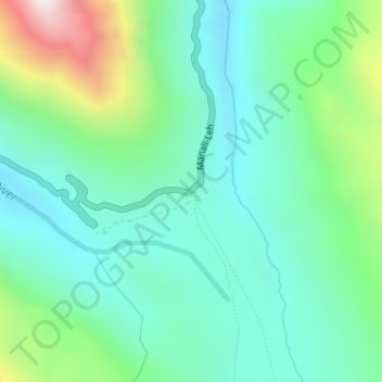
Naam: Topografische kaart Baralacha Pass, hoogte, reliëf.
Gemiddelde hoogte: 4.983 m
Minimale hoogte: 4.770 m
Maximale hoogte: 5.595 m
"The Bara Lacha is the boundary between two separate regions distinguished by their physical characteristics. That which we have already passed through may be called the true Himalayan region. Here the gigantic ranges are covered with perpetual snow, furrowed by glaciers, and they arise from amid dense forests which clothe their flanks up to a certain elevation. They are separated by deep gorges, whose sides are precipices, and though which large rivers flow. In fact the scenery is Alpine.
Andere topografische kaarten
Klik op een kaart om zijn topografie, zijn hoogte en zijn reliëf te bekijken.
Yamling
India > Himachal Pradesh > Lahul
Yamling, Lahul, Lahaul and Spiti District, Himachal Pradesh, India
Gemiddelde hoogte: 3.420 m
Rohtang Pass
India > Himachal Pradesh > Lahul
Rohtang Pass, Lahul, Lahul and Spiti, Himachal Pradesh, India
Gemiddelde hoogte: 4.042 m
Bara Shigri Glacier
India > Himachal Pradesh > Lahul
Bara Shigri Glacier, Lahul, Lahul and Spiti, Himachal Pradesh, India
Gemiddelde hoogte: 5.369 m
Sarchu
India > Himachal Pradesh > Lahul
Sarchu, Lahul, Lahul and Spiti, Himachal Pradesh, India
Gemiddelde hoogte: 5.408 m
Keylang
India > Himachal Pradesh > Lahul > Keylang
Keylang, Lahul, Lahul and Spiti, Himachal Pradesh, 175132, India
Gemiddelde hoogte: 3.827 m
Lahul
India > Himachal Pradesh > Lahul
Lahul, Lahul and Spiti, Himachal Pradesh, India
Gemiddelde hoogte: 4.551 m