
Topografische kaart Yamling
Interactieve kaart
Klik op de kaart om de hoogte weer te geven.
Over deze kaart
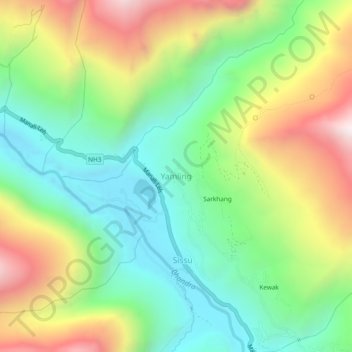
Naam: Topografische kaart Yamling, hoogte, reliëf.
Gemiddelde hoogte: 3.420 m
Minimale hoogte: 2.982 m
Maximale hoogte: 4.128 m
Andere topografische kaarten
Klik op een kaart om zijn topografie, zijn hoogte en zijn reliëf te bekijken.
Rohtang Pass
India > Himachal Pradesh > Lahul
Rohtang Pass, Lahul, Lahul and Spiti, Himachal Pradesh, India
Gemiddelde hoogte: 4.042 m
Bara Shigri Glacier
India > Himachal Pradesh > Lahul
Bara Shigri Glacier, Lahul, Lahul and Spiti, Himachal Pradesh, India
Gemiddelde hoogte: 5.369 m
Baralacha Pass
India > Himachal Pradesh > Lahul
Baralacha Pass, Lahul, Lahul and Spiti, Himachal Pradesh, India
Gemiddelde hoogte: 4.983 m
Sarchu
India > Himachal Pradesh > Lahul
Sarchu, Lahul, Lahul and Spiti, Himachal Pradesh, India
Gemiddelde hoogte: 5.408 m
Keylang
India > Himachal Pradesh > Lahul > Keylang
Keylang, Lahul, Lahul and Spiti, Himachal Pradesh, 175132, India
Gemiddelde hoogte: 3.827 m
Lahul
India > Himachal Pradesh > Lahul
Lahul, Lahul and Spiti, Himachal Pradesh, India
Gemiddelde hoogte: 4.551 m