
Topografische kaart Wake County
Interactieve kaart
Klik op de kaart om de hoogte weer te geven.
Over deze kaart
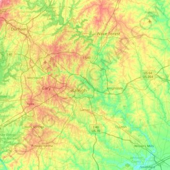
Naam: Topografische kaart Wake County, hoogte, reliëf.
Locatie: Wake County, North Carolina, United States of America (35.51941 -78.99505 36.07654 -78.25368)
Gemiddelde hoogte: 96 m
Minimale hoogte: 30 m
Maximale hoogte: 218 m
Wake County is located in the northeast central region of North Carolina, where the North American Piedmont and Atlantic Coastal Plain regions meet. This area is known as the "fall line" because it marks the elevation inland at which waterfalls begin to appear in creeks and rivers. As a result, most of Wake County features gently rolling hills that slope eastward toward the state's flat coastal plain. Its central Piedmont location situates the county about three hours west of Atlantic Beach, North Carolina, by car and four hours east of the Great Smoky Mountains.
Andere topografische kaarten
Klik op een kaart om zijn topografie, zijn hoogte en zijn reliëf te bekijken.
Mecklenburg County
United States of America > North Carolina
Mecklenburg County, North Carolina, United States of America
Gemiddelde hoogte: 208 m
Graham County
United States of America > North Carolina
Graham County, North Carolina, United States of America
Gemiddelde hoogte: 850 m
Davidson County
United States of America > North Carolina
Davidson County, North Carolina, United States of America
Gemiddelde hoogte: 222 m
Yancey County
United States of America > North Carolina
Yancey County, North Carolina, United States of America
Gemiddelde hoogte: 969 m