
Topografische kaart Graham County
Interactieve kaart
Klik op de kaart om de hoogte weer te geven.
Over deze kaart
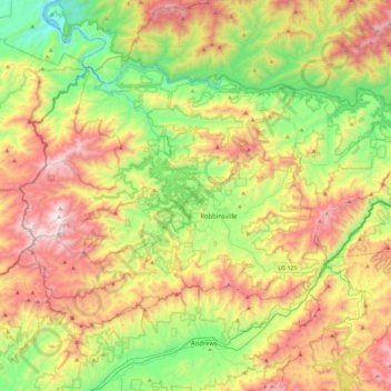
Naam: Topografische kaart Graham County, hoogte, reliëf.
Locatie: Graham County, North Carolina, United States of America (35.21693 -84.03889 35.46652 -83.58240)
Gemiddelde hoogte: 850 m
Minimale hoogte: 264 m
Maximale hoogte: 1.680 m
According to the U.S. Census Bureau, the county has a total area of 302 square miles (780 km2), of which 292 square miles (760 km2) is land and 9.6 square miles (25 km2) (3.2%) is water. The terrain of the county is mountainous, with elevations ranging from 1,177 feet (359 m) to 5,560 feet (1,690 m). Two-thirds of the county is the Nantahala National Forest. The soil of the valleys is fertile.
Andere topografische kaarten
Klik op een kaart om zijn topografie, zijn hoogte en zijn reliëf te bekijken.
Wake County
United States of America > North Carolina
Wake County, North Carolina, United States of America
Gemiddelde hoogte: 96 m
Mecklenburg County
United States of America > North Carolina
Mecklenburg County, North Carolina, United States of America
Gemiddelde hoogte: 208 m
Davidson County
United States of America > North Carolina
Davidson County, North Carolina, United States of America
Gemiddelde hoogte: 222 m
Yancey County
United States of America > North Carolina
Yancey County, North Carolina, United States of America
Gemiddelde hoogte: 969 m