
Topografische kaart Davidson County
Interactieve kaart
Klik op de kaart om de hoogte weer te geven.
Over deze kaart
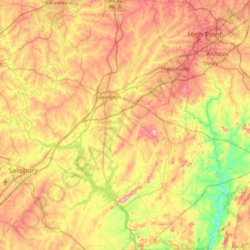
Naam: Topografische kaart Davidson County, hoogte, reliëf.
Locatie: Davidson County, North Carolina, United States of America (35.50419 -80.48771 36.02694 -80.04298)
Gemiddelde hoogte: 222 m
Minimale hoogte: 111 m
Maximale hoogte: 350 m
Davidson County is located entirely within the Piedmont region of central North Carolina. The Piedmont consists of gently rolling terrain frequently broken by hills or shallow valleys formed by rivers and streams. An exception to this terrain are the Uwharrie Mountains in the county's western and southwestern sections. The Uwharries are the oldest mountain range in North America, and at one time they rose to nearly 20,000 feet (6,100 m) above sea level. However, time has worn them down to little more than high hills; yet due to the relative flatness of the surrounding countryside they still rise from 250 to 500 feet (150 m) above their base. The highest point in the Uwharries - and the highest point in Davidson County - is High Rock Mountain in the county's southwestern corner. It has an elevation of 1,119 feet (341 m) above sea level.
Andere topografische kaarten
Klik op een kaart om zijn topografie, zijn hoogte en zijn reliëf te bekijken.
Wake County
United States of America > North Carolina
Wake County, North Carolina, United States of America
Gemiddelde hoogte: 96 m
Mecklenburg County
United States of America > North Carolina
Mecklenburg County, North Carolina, United States of America
Gemiddelde hoogte: 208 m
Graham County
United States of America > North Carolina
Graham County, North Carolina, United States of America
Gemiddelde hoogte: 850 m
Yancey County
United States of America > North Carolina
Yancey County, North Carolina, United States of America
Gemiddelde hoogte: 969 m