
Topografische kaart Chelsea
Interactieve kaart
Klik op de kaart om de hoogte weer te geven.
Over deze kaart
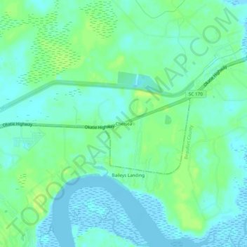
Naam: Topografische kaart Chelsea, hoogte, reliëf.
Locatie: Chelsea, Jasper County, South Carolina, United States (32.33436 -80.90816 32.37436 -80.86816)
Gemiddelde hoogte: 6 m
Minimale hoogte: -5 m
Maximale hoogte: 15 m
Andere topografische kaarten
Klik op een kaart om zijn topografie, zijn hoogte en zijn reliëf te bekijken.
Tillman
United States > South Carolina > Jasper County
Tillman, Jasper County, South Carolina, 29943, United States
Gemiddelde hoogte: 15 m
Hardeeville
United States > South Carolina > Jasper County
Hardeeville, Jasper County, South Carolina, United States
Gemiddelde hoogte: 5 m
Murad
United States > South Carolina > Jasper County
Murad, Jasper County, South Carolina, United States
Gemiddelde hoogte: 4 m
Honey Hill
United States > South Carolina > Jasper County
Honey Hill, Jasper County, South Carolina, 29936, United States
Gemiddelde hoogte: 14 m
Hilton Head Lakes North
United States > South Carolina > Jasper County > Hardeeville
Hilton Head Lakes North, Hardeeville, Jasper County, South Carolina, United States
Gemiddelde hoogte: 3 m
Latitude Margaritaville
United States > South Carolina > Jasper County > Hardeeville
Latitude Margaritaville, Hardeeville, Jasper County, South Carolina, 29927, United States
Gemiddelde hoogte: 4 m
Sun City
United States > South Carolina > Jasper County > Hardeeville
Sun City, Hardeeville, Jasper County, South Carolina, 29909, United States
Gemiddelde hoogte: 6 m
Ridgeland
United States > South Carolina > Jasper County
Ridgeland, Jasper County, South Carolina, 29936, United States
Gemiddelde hoogte: 15 m