
Topografische kaart Ridgeland
Interactieve kaart
Klik op de kaart om de hoogte weer te geven.
Over deze kaart
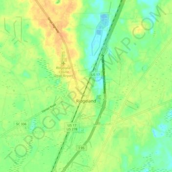
Naam: Topografische kaart Ridgeland, hoogte, reliëf.
Gemiddelde hoogte: 15 m
Minimale hoogte: -3 m
Maximale hoogte: 32 m
Ridgeland is in northeastern Jasper County, with the center of town sitting on a low ridge at an elevation of 62 feet (19 m) above sea level. According to the United States Census Bureau, the town has a total area of 44.7 square miles (115.8 km2), of which 44.4 square miles (115.1 km2) are land and 0.3 square miles (0.7 km2), or 0.59%, are water. The town's area as of 2010 was 18 times greater than its 2000 area of 2.4 square miles (6.3 km2). The town limits now extend east into Beaufort County as far as the west bank of the Broad River.
Andere topografische kaarten
Klik op een kaart om zijn topografie, zijn hoogte en zijn reliëf te bekijken.
Tillman
United States > South Carolina > Jasper County
Tillman, Jasper County, South Carolina, 29943, United States
Gemiddelde hoogte: 15 m
Hardeeville
United States > South Carolina > Jasper County
Hardeeville, Jasper County, South Carolina, United States
Gemiddelde hoogte: 5 m
Murad
United States > South Carolina > Jasper County
Murad, Jasper County, South Carolina, United States
Gemiddelde hoogte: 4 m
Honey Hill
United States > South Carolina > Jasper County
Honey Hill, Jasper County, South Carolina, 29936, United States
Gemiddelde hoogte: 14 m
Hilton Head Lakes North
United States > South Carolina > Jasper County > Hardeeville
Hilton Head Lakes North, Hardeeville, Jasper County, South Carolina, United States
Gemiddelde hoogte: 3 m
Latitude Margaritaville
United States > South Carolina > Jasper County > Hardeeville
Latitude Margaritaville, Hardeeville, Jasper County, South Carolina, 29927, United States
Gemiddelde hoogte: 4 m
Chelsea
United States > South Carolina > Jasper County
Chelsea, Jasper County, South Carolina, United States
Gemiddelde hoogte: 6 m
Sun City
United States > South Carolina > Jasper County > Hardeeville
Sun City, Hardeeville, Jasper County, South Carolina, 29909, United States
Gemiddelde hoogte: 6 m