
Topografische kaart Clingmans Dome
Interactieve kaart
Klik op de kaart om de hoogte weer te geven.
Over deze kaart
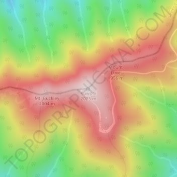
Naam: Topografische kaart Clingmans Dome, hoogte, reliëf.
Locatie: Clingmans Dome, Swain County, North Carolina, United States (35.56281 -83.49843 35.56291 -83.49833)
Gemiddelde hoogte: 1.716 m
Minimale hoogte: 1.370 m
Maximale hoogte: 2.021 m
Clingmans Dome (or Clingman's Dome) is a mountain in the Great Smoky Mountains of Tennessee and North Carolina in the southeastern United States. Its name in Cherokee is Kuwahi or Kuwohi (ᎫᏩᎯ or ᎫᏬᎯ), meaning "mulberry place." At an elevation of 6,643 feet (2,025 m), it is the highest mountain in the Great Smoky Mountains National Park, the highest point in the state of Tennessee, and the highest point along the 2,192-mile (3,528 km) Appalachian Trail. It is also the third highest point in mainland Eastern North America, after Mount Mitchell (6,684 feet or 2,037 metres) and Mount Craig (6,647 feet or 2,026 metres).
Andere topografische kaarten
Klik op een kaart om zijn topografie, zijn hoogte en zijn reliëf te bekijken.
Bryson City
United States > North Carolina > Swain County
Bryson City, Swain County, North Carolina, United States
Gemiddelde hoogte: 592 m
Smokemont
United States > North Carolina > Swain County
Smokemont, Swain County, North Carolina, United States
Gemiddelde hoogte: 898 m
Alarka
United States > North Carolina > Swain County
Alarka, Swain County, North Carolina, 28813, United States
Gemiddelde hoogte: 837 m
Fontana Lake
United States > North Carolina > Swain County
Fontana Lake, Swain County, North Carolina, United States
Gemiddelde hoogte: 806 m
Rye Patch
United States > North Carolina > Swain County
Rye Patch, Swain County, North Carolina, United States
Gemiddelde hoogte: 1.190 m
Big Cove Community
United States > North Carolina > Swain County
Big Cove Community, Swain County, North Carolina, United States
Gemiddelde hoogte: 1.009 m
Cheoah Bald
United States > North Carolina > Swain County
Cheoah Bald, Swain County, North Carolina, United States
Gemiddelde hoogte: 1.274 m
Almond
United States > North Carolina > Swain County
Almond, Swain County, North Carolina, 28702, United States
Gemiddelde hoogte: 608 m
Fontana Dam
United States > North Carolina > Swain County
Fontana Dam, Swain County, North Carolina, United States
Gemiddelde hoogte: 525 m
Nantahala
United States > North Carolina > Swain County
Nantahala, Swain County, North Carolina, United States
Gemiddelde hoogte: 890 m
Wesser
United States > North Carolina > Swain County > Wesser
Wesser, Swain County, North Carolina, 28702-9603, United States
Gemiddelde hoogte: 672 m
Whittier
United States > North Carolina > Swain County
Whittier, Swain County, North Carolina, 28789, United States
Gemiddelde hoogte: 624 m
Cherokee
United States > North Carolina > Swain County > Yellowhill Community
Cherokee, Yellowhill Community, Swain County, North Carolina, 28719, United States
Gemiddelde hoogte: 746 m