
Topografische kaart Fontana Lake
Interactieve kaart
Klik op de kaart om de hoogte weer te geven.
Over deze kaart
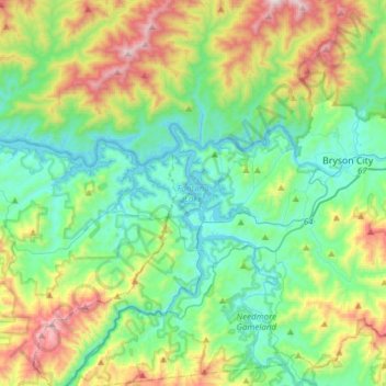
Naam: Topografische kaart Fontana Lake, hoogte, reliëf.
Locatie: Fontana Lake, Swain County, North Carolina, United States (35.33446 -83.80977 35.48456 -83.50520)
Gemiddelde hoogte: 806 m
Minimale hoogte: 497 m
Maximale hoogte: 1.599 m
Fontana Lake provides the only access into the most remote areas of the National Park, unless visitors undertake a multi-day hike to get there. When the lake is at the normal summer level, a boat may be used to access remote trailheads such as Hazel Creek. From the observation tower on Clingmans Dome, on a clear day the lake can be seen nearly a mile below. While the maximum controlled elevation of the lake (top of dam gates) is 1,710 ft (520 m), the normal Summer surface elevation is 1,703 ft (519 m). NC 28 roughly parallels the southern shore of the lake, and US 19, between Bryson City and Wesser/Lauada, briefly skims an inlet at the extreme southeastern edge.
Andere topografische kaarten
Klik op een kaart om zijn topografie, zijn hoogte en zijn reliëf te bekijken.
Bryson City
United States > North Carolina > Swain County
Bryson City, Swain County, North Carolina, United States
Gemiddelde hoogte: 592 m
Smokemont
United States > North Carolina > Swain County
Smokemont, Swain County, North Carolina, United States
Gemiddelde hoogte: 898 m
Alarka
United States > North Carolina > Swain County
Alarka, Swain County, North Carolina, 28813, United States
Gemiddelde hoogte: 837 m
Rye Patch
United States > North Carolina > Swain County
Rye Patch, Swain County, North Carolina, United States
Gemiddelde hoogte: 1.190 m
Big Cove Community
United States > North Carolina > Swain County
Big Cove Community, Swain County, North Carolina, United States
Gemiddelde hoogte: 1.009 m
Cheoah Bald
United States > North Carolina > Swain County
Cheoah Bald, Swain County, North Carolina, United States
Gemiddelde hoogte: 1.274 m
Almond
United States > North Carolina > Swain County
Almond, Swain County, North Carolina, 28702, United States
Gemiddelde hoogte: 608 m
Fontana Dam
United States > North Carolina > Swain County
Fontana Dam, Swain County, North Carolina, United States
Gemiddelde hoogte: 525 m
Nantahala
United States > North Carolina > Swain County
Nantahala, Swain County, North Carolina, United States
Gemiddelde hoogte: 890 m
Wesser
United States > North Carolina > Swain County > Wesser
Wesser, Swain County, North Carolina, 28702-9603, United States
Gemiddelde hoogte: 672 m
Whittier
United States > North Carolina > Swain County
Whittier, Swain County, North Carolina, 28789, United States
Gemiddelde hoogte: 624 m
Clingmans Dome
United States > North Carolina > Swain County
Clingmans Dome, Swain County, North Carolina, United States
Gemiddelde hoogte: 1.716 m
Cherokee
United States > North Carolina > Swain County > Yellowhill Community
Cherokee, Yellowhill Community, Swain County, North Carolina, 28719, United States
Gemiddelde hoogte: 746 m