
Topografische kaart Outwood
Klik op de kaart om de hoogte weer te geven.
Over deze kaart
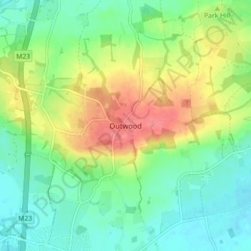
Naam: Topografische kaart Outwood, hoogte, reliëf.
Locatie: Outwood, Tandridge, Surrey, England, RH1 5PW, United Kingdom (51.17317 -0.12176 51.21317 -0.08176)
Gemiddelde hoogte: 78 m
Minimale hoogte: 52 m
Maximale hoogte: 123 m
Andere topografische kaarten
Klik op een kaart om zijn topografie, zijn hoogte en zijn reliëf te bekijken.
Surrey
United Kingdom > England > Surrey
The highest elevation in Surrey is Leith Hill near Dorking. It is 295 m (968 ft) above sea level and is the second highest point in southeastern England after Walbury Hill in West Berkshire which is 297 m (974 ft).
Gemiddelde hoogte: 69 m
Stratton Brook
United Kingdom > England > Surrey > Tandridge > Godstone > Church Town
Gemiddelde hoogte: 117 m
Addlestone
United Kingdom > England > Surrey > Borough of Runnymede
Elevations range between 11 metres (36 ft) and 40 metres (130 ft). The maximum is on Row Hill recreation ground, Row Town, Addlestone; a ridge that continues to the northwest of Row Town where it is known as Ongar/Spinney Hill, where Great Grove Farm in its centre also reaches this height; the minimum is by…
Gemiddelde hoogte: 18 m
Godalming
United Kingdom > England > Surrey > Waverley
Elevations vary between 36 m (118 ft) AOD by the Guildford Road Rugby Union ground and Broadwater lake at the River Wey's exit from Godalming into Peasmarsh, Shalford, and 106 m (347.76 ft) AOD where Quarter Mile meets Hambledon Road (both residential) in the south-east. Hurtmore Road is also residential:…
Gemiddelde hoogte: 71 m
Shalford
United Kingdom > England > Surrey > Guildford > Guildford
Lt.Col. Henry Haversham Godwin-Austen (1834–1923), topographer, geologist, naturalist and explorer who surveyed the Himalayan region, including K2, sometimes known as Mt. Godwin-Austen, for a time had an estate in Shalford.
Gemiddelde hoogte: 54 m
Esher
United Kingdom > England > Surrey > Elmbridge
Esher is an outlying suburb of London, close to the London–Surrey border; with Esher Commons at its southern end, the town marks one limit of the Greater London Built-Up Area. Esher has a linear commercial high street and is otherwise suburban in density, with varying elevations, few high rise buildings and…
Gemiddelde hoogte: 21 m
Cranleigh
United Kingdom > England > Surrey > Waverley
Elevations range from a maximum of 240 m AOD (mean high water level) at the car park on Reynolds Hill in Winterfold Heath (a woodland in the north) to 41 m on the watercourse and the disused Wey and Arun Canal as they leave both the parish in the northwest extreme at the end of East Whipley Lane. The village…
Gemiddelde hoogte: 78 m
Farnham
United Kingdom > England > Surrey > Waverley
Farnham lies in the valley of the North Branch of the River Wey, which rises near Alton, merges with the South Branch at Tilford, and joins the River Thames at Weybridge. The mainly east-west alignment of the ridges and valleys has influenced the development of road and rail communications. The most prominent…
Gemiddelde hoogte: 100 m
Haslemere
United Kingdom > England > Surrey > Waverley > Shottermill
Many of the roads in the area originated as medieval tracks and owing to the local topography, are narrow, twisting and steep. The principal route through Haslemere is the A286, which connects the town with Godalming and Grayswood (to the north) and with Midhurst (to the south). The A287 runs south from…
Gemiddelde hoogte: 150 m
Cobham
United Kingdom > England > Surrey > Elmbridge
The River Mole runs through Cobham, with a visitor area and well-surfaced path by the mill in the High Street, dividing the low-rise urban village/town centre from the remaining agricultural parts of Cobham in the west and south. This can flood small, old parts of the village centre in extreme rainfall.…
Gemiddelde hoogte: 28 m
Staines-upon-Thames
United Kingdom > England > Surrey
Much of the town is built on gravel "islands" that rise above the low-lying floodplains of the Thames and Colne. These gravel deposits have a typical maximum elevation of 14 m (46 ft) above ordnance datum (AOD) and are as little as 0.5 m (1.6 ft) above the surrounding floodplain. Staines High Street, oriented…
Gemiddelde hoogte: 16 m
Chertsey
United Kingdom > England > Surrey > Borough of Runnymede
Samuel Lewis devotes one of his longest entries to the small town in his 1848 topographical guide to England.
Gemiddelde hoogte: 17 m
Epsom and Ewell
United Kingdom > England > Surrey
The borough is at a range of elevations, scaling the lower slopes of the North Downs and drains into a large stream which springs above the surface in Ewell, the Hogsmill River which drains into the Thames at Kingston. The borough comprises.
Gemiddelde hoogte: 73 m
Reigate and Banstead
United Kingdom > England > Surrey
The softer Greensand Ridge which is parallel to the south breaks up in the middle of the borough, forming the Redhill basin and various mounds around Reigate before continuing in both directions at higher elevations, see the Greensand Way. The Mole forms a section of the western border of the borough down to…
Gemiddelde hoogte: 105 m
Lingfield
United Kingdom > England > Surrey
Elevations range between 76m AOD in Lingfield Park Golf Course adjoining Lingfield Park and Felcourt to 46.5m AOD along the northern border, the Eden Brook from Moat Farm to the railway line.
Gemiddelde hoogte: 64 m
Bagshot Park Mansion
United Kingdom > England > Surrey > Surrey Heath > Bagshot
Gemiddelde hoogte: 76 m
Chobham Common
United Kingdom > England > Surrey > Surrey Heath > Chobham > Brick Hill
Gemiddelde hoogte: 49 m
Warlingham
United Kingdom > England > Surrey > Tandridge
Elevations vary from 110m AOD at Woldingham Road, at the southernmost point of the parish, with a gentle increase in height through the village along the main road heading to the southeast, to the highest elevation (199.6m) at Limpsfield Road.
Gemiddelde hoogte: 163 m
Horsell Common
United Kingdom > England > Surrey > Woking > Horsell > Durnford Farm
Gemiddelde hoogte: 29 m
Felbridge
United Kingdom > England > Surrey
Elevations range between 115m AOB towards the south of the eastern boundary, fields adjoining Chartham Wood and similarly 102m AOB along West Park Road by the Effingham Park Hotel in the southwest, to 53m AOB along Felbridge Water between Felcourt and Newchapel, in the northeast of the parish, a tributary of…
Gemiddelde hoogte: 75 m
Lower Earlswood Lake
United Kingdom > England > Surrey > Reigate and Banstead > Redhill
Gemiddelde hoogte: 75 m
Cranleigh Waters or Bramley Wey
United Kingdom > England > Surrey > Guildford > Shalford
Gemiddelde hoogte: 52 m
Frimley Lodge Park
United Kingdom > England > Surrey > Surrey Heath > Frimley Green
Gemiddelde hoogte: 80 m
Hankley Common
United Kingdom > England > Surrey > Waverley > Thursley > Truxford
Gemiddelde hoogte: 70 m
Redhill Common
United Kingdom > England > Surrey > Reigate and Banstead > Redhill
Gemiddelde hoogte: 92 m
Banstead Wood
United Kingdom > England > Surrey > Reigate and Banstead > Chipstead
Gemiddelde hoogte: 145 m
Reigate Park
United Kingdom > England > Surrey > Reigate and Banstead > Reigate
Gemiddelde hoogte: 80 m
Chobham
United Kingdom > England > Surrey > Surrey Heath
The rolling basin below reaches lowest elevations of between 30 metres (98 ft) in the centre of the west and 20 metres (66 ft) where the rivers join in the centre of the east. The rivers at the western point are less than 100 metres (330 ft) apart; to the east end of the parish where the parish adjoins the…
Gemiddelde hoogte: 43 m
Queen Mary Reservoir
United Kingdom > England > Surrey > Borough of Spelthorne > Charlton
Gemiddelde hoogte: 14 m
Witley
United Kingdom > England > Surrey > Waverley
In 1848, Samuel Lewis's "topographical dictionary of England" describes Witley as
Gemiddelde hoogte: 89 m