
Topografische kaart Addlestone
Klik op de kaart om de hoogte weer te geven.
Addlestone
Elevations range between 11 metres (36 ft) and 40 metres (130 ft). The maximum is on Row Hill recreation ground, Row Town, Addlestone; a ridge that continues to the northwest of Row Town where it is known as Ongar/Spinney Hill, where Great Grove Farm in its centre also reaches this height; the minimum is by the Thames and along the Woburn Park Stream which is the main distributary of The Bourne the main waterway of the village, a stream rising as the Windle Brook in Windlesham cutting a shallow ravine, flowing past the McLaren Technology Centre and Woodham then passing to the east of the village.
Over deze kaart
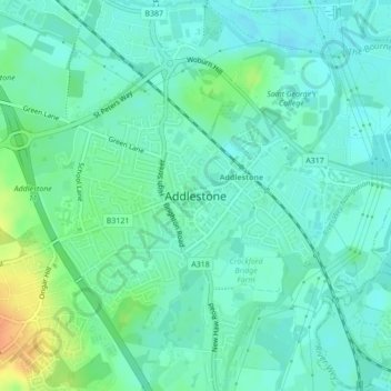
Naam: Topografische kaart Addlestone, hoogte, reliëf.
Gemiddelde hoogte: 18 m
Minimale hoogte: 8 m
Maximale hoogte: 45 m
Andere topografische kaarten
Klik op een kaart om zijn topografie, zijn hoogte en zijn reliëf te bekijken.
Cooper's Hill Slopes
United Kingdom > England > Surrey > Borough of Runnymede > Englefield Green
Gemiddelde hoogte: 38 m
Chertsey
United Kingdom > England > Surrey > Borough of Runnymede
Samuel Lewis devotes one of his longest entries to the small town in his 1848 topographical guide to England.
Gemiddelde hoogte: 22 m
Egham Wick
United Kingdom > England > Surrey > Borough of Runnymede > Englefield Green
Gemiddelde hoogte: 55 m
Lyn Mushroom Farm
United Kingdom > England > Surrey > Borough of Runnymede > Lyne
Gemiddelde hoogte: 39 m
Chertsey
United Kingdom > England > Surrey > Borough of Runnymede
Samuel Lewis devotes one of his longest entries to the small town in his 1848 topographical guide to England.
Gemiddelde hoogte: 22 m