
Topografische kaart Southern District
Interactieve kaart
Klik op de kaart om de hoogte weer te geven.
Over deze kaart
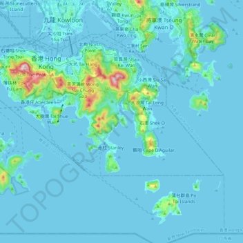
Naam: Topografische kaart Southern District, hoogte, reliëf.
Locatie: Southern District, Hong Kong Island, Hongkong, China (22.19265 114.11011 22.27561 114.30905)
Gemiddelde hoogte: 36 m
Minimale hoogte: -6 m
Maximale hoogte: 532 m
Andere topografische kaarten
Klik op een kaart om zijn topografie, zijn hoogte en zijn reliëf te bekijken.
扯旗山 Victoria Peak
China > Hongkong > Hong Kong Island
扯旗山 Victoria Peak, Hong Kong Island, Hongkong, China
Gemiddelde hoogte: 209 m
Victoria Peak Lookout (over the Victoria Harbour)
China > Hongkong > Hong Kong Island
Victoria Peak Lookout (over the Victoria Harbour), 盧吉道 Lugard Road, 太平山 Victoria Peak, 山頂 The Peak, 中西區 Central and Western District, Hong Kong Island, Hongkong, China
Gemiddelde hoogte: 191 m
中區 Central District
China > Hongkong > Hong Kong Island
中區 Central District, Hong Kong Island, Hongkong, China
Gemiddelde hoogte: 114 m