
Topografische kaart Victoria Peak Lookout (over the Victoria Harbour)
Interactieve kaart
Klik op de kaart om de hoogte weer te geven.
Over deze kaart
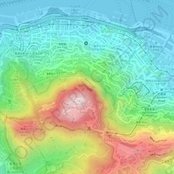
Naam: Topografische kaart Victoria Peak Lookout (over the Victoria Harbour), hoogte, reliëf.
Gemiddelde hoogte: 191 m
Minimale hoogte: -2 m
Maximale hoogte: 534 m
Andere topografische kaarten
Klik op een kaart om zijn topografie, zijn hoogte en zijn reliëf te bekijken.
扯旗山 Victoria Peak
China > Hongkong > Hong Kong Island
扯旗山 Victoria Peak, Hong Kong Island, Hongkong, China
Gemiddelde hoogte: 209 m
Southern District
China > Hongkong > Hong Kong Island
Southern District, Hong Kong Island, Hongkong, China
Gemiddelde hoogte: 36 m
中區 Central District
China > Hongkong > Hong Kong Island
中區 Central District, Hong Kong Island, Hongkong, China
Gemiddelde hoogte: 114 m