
Topografische kaart 扯旗山 Victoria Peak
Interactieve kaart
Klik op de kaart om de hoogte weer te geven.
Over deze kaart
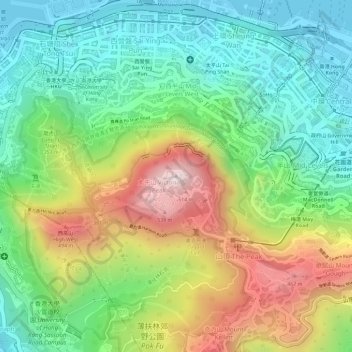
Naam: Topografische kaart 扯旗山 Victoria Peak, hoogte, reliëf.
Locatie: 扯旗山 Victoria Peak, Hong Kong Island, Hongkong, China (22.27599 114.14541 22.27609 114.14551)
Gemiddelde hoogte: 209 m
Minimale hoogte: -2 m
Maximale hoogte: 534 m
Der Victoria Peak (chinesisch 太平山, Pinyin Tàipíng Shān, Jyutping Taai3ping4 Saan1 – „Friedensberg“) mit 552 Metern Höhe ist der bekannteste Berg Hongkongs. Auf Hong Kong Island gelegen, ist er zugleich die höchste Erhebung dieser Insel, wird jedoch vom 958 Meter hohen, in den New Territories gelegenen Tai Mo Shan deutlich überragt. Sein chinesischer Name Tai Ping Shan bedeutet „Berg des großen Friedens“. Der Gipfel bietet einen weiten Blick über Kowloon und große Teile der Insel Hongkong.
Andere topografische kaarten
Klik op een kaart om zijn topografie, zijn hoogte en zijn reliëf te bekijken.
Victoria Peak Lookout (over the Victoria Harbour)
China > Hongkong > Hong Kong Island
Victoria Peak Lookout (over the Victoria Harbour), 盧吉道 Lugard Road, 太平山 Victoria Peak, 山頂 The Peak, 中西區 Central and Western District, Hong Kong Island, Hongkong, China
Gemiddelde hoogte: 191 m
Southern District
China > Hongkong > Hong Kong Island
Southern District, Hong Kong Island, Hongkong, China
Gemiddelde hoogte: 36 m
中區 Central District
China > Hongkong > Hong Kong Island
中區 Central District, Hong Kong Island, Hongkong, China
Gemiddelde hoogte: 114 m