
Topografische kaart Elko County
Interactieve kaart
Klik op de kaart om de hoogte weer te geven.
Over deze kaart
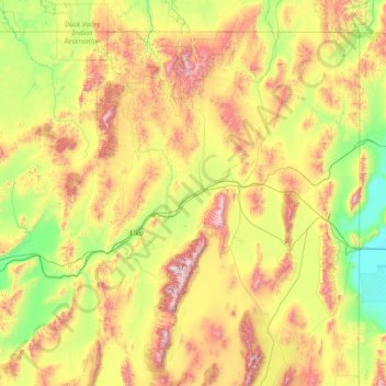
Naam: Topografische kaart Elko County, hoogte, reliëf.
Locatie: Elko County, Nevada, United States of America (40.11784 -117.01775 42.00221 -114.03965)
Gemiddelde hoogte: 1.838 m
Minimale hoogte: 1.283 m
Maximale hoogte: 3.337 m
According to the U.S. Census Bureau, the county has a total area of 17,203 square miles (44,560 km2), of which 17,170 square miles (44,500 km2) is land and 33 square miles (85 km2) (0.2%) is water. Not counting Alaska's boroughs (four of which are also larger), it is the fourth-largest county in area in the United States (behind San Bernardino County, California, Coconino County, Arizona, and Nye County, Nevada). The elevation ranges from about 4,300 feet (1,300 m) at the edge of the salt flats of the Great Salt Lake Desert, to 11,387 feet (3,471 m) on the summit of Ruby Dome in the Ruby Mountains. The most topographically prominent mountain in Elko County is Pilot Peak.
Andere topografische kaarten
Klik op een kaart om zijn topografie, zijn hoogte en zijn reliëf te bekijken.
Pershing County
United States of America > Nevada
Pershing County, Nevada, United States of America
Gemiddelde hoogte: 1.449 m
Esmeralda County
United States of America > Nevada
Esmeralda County, Nevada, United States of America
Gemiddelde hoogte: 1.789 m
Washoe County
United States of America > Nevada
Washoe County, Nevada, United States of America
Gemiddelde hoogte: 1.528 m
Churchill County
United States of America > Nevada
Churchill County, Nevada, United States of America
Gemiddelde hoogte: 1.476 m
White Pine County
United States of America > Nevada
White Pine County, Nevada, United States of America
Gemiddelde hoogte: 2.049 m