
Topografische kaart White Pine County
Interactieve kaart
Klik op de kaart om de hoogte weer te geven.
Over deze kaart
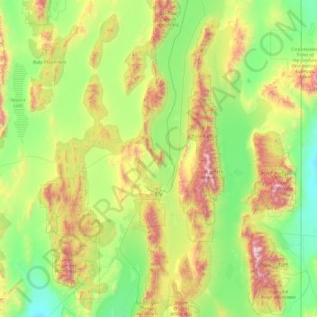
Naam: Topografische kaart White Pine County, hoogte, reliëf.
Locatie: White Pine County, Nevada, United States of America (38.67751 -115.90822 40.12890 -114.04639)
Gemiddelde hoogte: 2.049 m
Minimale hoogte: 1.468 m
Maximale hoogte: 3.839 m
In the southeastern part of the county within Great Basin National Park lies 13,065 ft (3982 m) Wheeler Peak, the tallest independent mountain within Nevada and the second-highest point within the state (the highest point being Boundary Peak). It is also the most topographically prominent peak in the county and the second-most prominent peak in Nevada (after Mount Charleston).
Andere topografische kaarten
Klik op een kaart om zijn topografie, zijn hoogte en zijn reliëf te bekijken.
Pershing County
United States of America > Nevada
Pershing County, Nevada, United States of America
Gemiddelde hoogte: 1.449 m
Esmeralda County
United States of America > Nevada
Esmeralda County, Nevada, United States of America
Gemiddelde hoogte: 1.789 m
Washoe County
United States of America > Nevada
Washoe County, Nevada, United States of America
Gemiddelde hoogte: 1.528 m
Churchill County
United States of America > Nevada
Churchill County, Nevada, United States of America
Gemiddelde hoogte: 1.476 m
Elko County
United States of America > Nevada
Elko County, Nevada, United States of America
Gemiddelde hoogte: 1.838 m