
Topografische kaart Washoe County
Interactieve kaart
Klik op de kaart om de hoogte weer te geven.
Over deze kaart
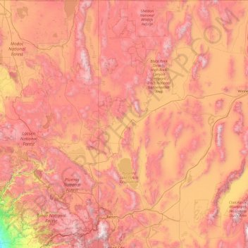
Naam: Topografische kaart Washoe County, hoogte, reliëf.
Locatie: Washoe County, Nevada, United States of America (39.16544 -120.00573 41.99764 -119.17271)
Gemiddelde hoogte: 1.528 m
Minimale hoogte: 30 m
Maximale hoogte: 3.161 m
According to the U.S. Census Bureau, the county has a total area of 6,542 square miles (16,940 km2), of which 6,302 square miles (16,320 km2) is land and 240 square miles (620 km2) (3.7%) is water. The highest point in Washoe County is Mount Rose at 10,785 ft (3,287 m), while the most topographically prominent peak is Virginia Peak.
Andere topografische kaarten
Klik op een kaart om zijn topografie, zijn hoogte en zijn reliëf te bekijken.
Pershing County
United States of America > Nevada
Pershing County, Nevada, United States of America
Gemiddelde hoogte: 1.449 m
Esmeralda County
United States of America > Nevada
Esmeralda County, Nevada, United States of America
Gemiddelde hoogte: 1.789 m
Churchill County
United States of America > Nevada
Churchill County, Nevada, United States of America
Gemiddelde hoogte: 1.476 m
Elko County
United States of America > Nevada
Elko County, Nevada, United States of America
Gemiddelde hoogte: 1.838 m
White Pine County
United States of America > Nevada
White Pine County, Nevada, United States of America
Gemiddelde hoogte: 2.049 m