
Topografische kaart Mabe
Klik op de kaart om de hoogte weer te geven.
Over deze kaart
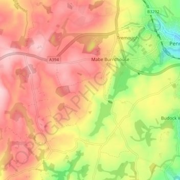
Naam: Topografische kaart Mabe, hoogte, reliëf.
Locatie: Mabe, Cornwall, England, United Kingdom (50.13185 -5.17151 50.18014 -5.11701)
Gemiddelde hoogte: 122 m
Minimale hoogte: 5 m
Maximale hoogte: 202 m
Andere topografische kaarten
Klik op een kaart om zijn topografie, zijn hoogte en zijn reliëf te bekijken.
Bude
United Kingdom > England > Cornwall
Its earlier importance was as a harbour, and then a source of sea sand useful for improving the inland soil. This was transported on the Bude Canal. The Victorians favoured it as a seaside resort. With new rail links, it became a popular seaside destination in the 20th century. Bradshaw's Guide of 1866,…
Gemiddelde hoogte: 41 m