
Topografische kaart Independence Rock
Interactieve kaart
Klik op de kaart om de hoogte weer te geven.
Over deze kaart
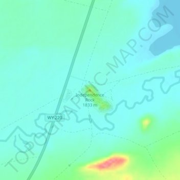
Naam: Topografische kaart Independence Rock, hoogte, reliëf.
Gemiddelde hoogte: 1.802 m
Minimale hoogte: 1.786 m
Maximale hoogte: 1.871 m
Andere topografische kaarten
Klik op een kaart om zijn topografie, zijn hoogte en zijn reliëf te bekijken.
Pinedale
United States of America > Wyoming > Pinedale
Pinedale, Sublette County, Wyoming, United States of America
Gemiddelde hoogte: 2.199 m
Burgess Junction
United States of America > Wyoming > Burgess Junction
Burgess Junction, Sheridan County, Wyoming, United States of America
Gemiddelde hoogte: 2.459 m
Etna
United States of America > Wyoming
Etna, Lincoln County, Wyoming, United States of America
Gemiddelde hoogte: 1.765 m
Red Butte
United States of America > Wyoming > Red Butte
Red Butte, Natrona County, Wyoming, 82604, United States of America
Gemiddelde hoogte: 1.606 m
Wilson
United States of America > Wyoming > Wilson
Wilson, Teton County, Wyoming, United States of America
Gemiddelde hoogte: 1.953 m
Bison Peak
United States of America > Wyoming
Bison Peak, Park County, Wyoming, United States of America
Gemiddelde hoogte: 2.447 m
Seminoe Dam
United States of America > Wyoming
Seminoe Dam, Carbon County, Wyoming, United States of America
Gemiddelde hoogte: 2.067 m
Collins Place
United States of America > Wyoming > Collins Place
Collins Place, Fremont County, Wyoming, United States of America
Gemiddelde hoogte: 2.146 m