
Topografische kaart Guayama
Interactieve kaart
Klik op de kaart om de hoogte weer te geven.
Over deze kaart
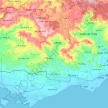
Naam: Topografische kaart Guayama, hoogte, reliëf.
Locatie: Guayama, Puerto Rico, United States (17.92839 -66.21349 18.10760 -66.05307)
Gemiddelde hoogte: 274 m
Minimale hoogte: -2 m
Maximale hoogte: 886 m
The Municipality of Guayama is located on the Southern Coastal Valley region, bordering the Caribbean Sea, south of Cayey; east of Salinas; and west of Patillas and Arroyo. Guayama's municipal territory reaches the central mountain range to the north and the Caribbean Sea to the south. The mountain systems Sierra de Jájome (2,395 feet or 730 meters) and Sierra de Cayey cover some of the municipality area. The highest points are the Cerro de la Tabla (2,834 feet or 863 meters) and Cerro Tumbado (2,450 feet or 746 meters), which are part of the Sierra de Cayey mountain system. Other elevations are the mountains Garau, Charcas and Peña Hendida. Parts of the Guavate-Carite Forest and the Aguirre State Forest are in Guayama. The Guavate-Carite Forest, a 6,000-acre nature reserve is inhabited by 50 species of birds, making this spot a recognized area for birding and has a reserve with a dwarf forest that was produced by the region's high humidity and moist soil. The Aguirre Forest includes: mangroves, tidal flats, bird rookeries, research lakes & large manatee population. The Jobos Bay National Estuarine Research Reserve was established in 1987. The reserve is located between the coasts of Salinas and Guayama, approximately 2,883 acres of mangrove forest and freshwater wetlands. The two main components: Mar Negro mangrove forest, which consists of a mangrove forest and a complex system of lagoons and channels interspersed with salt and mud flats; and Cayos Caribe Islets, which are surrounded by coral reefs and seagrass beds, with small beach deposits and upland areas.
Andere topografische kaarten
Klik op een kaart om zijn topografie, zijn hoogte en zijn reliëf te bekijken.
Rincón
United States > Puerto Rico > Cidra
Rincón, Cidra, Puerto Rico, United States
Gemiddelde hoogte: 419 m
Sector Pepe Morales
United States > Puerto Rico > Naranjito > Naranjito
Sector Pepe Morales, Cedro Abajo, Naranjito, Puerto Rico, 00719, United States
Gemiddelde hoogte: 422 m
San Isidro
United States > Puerto Rico > Canóvanas
San Isidro, Canóvanas, Puerto Rico, United States
Gemiddelde hoogte: 29 m
Florida
Florida, Puerto Rico, 00650, United States
Gemiddelde hoogte: 200 m
Cerro Gonzalo
United States > Puerto Rico > Aguadilla
Cerro Gonzalo, Barrio Pueblo, Aguadilla, Puerto Rico, 00605, United States
Gemiddelde hoogte: 58 m
Rincón
United States > Puerto Rico > Cayey
Rincón, Cayey, Puerto Rico, 00737, United States
Gemiddelde hoogte: 393 m
Hatillo
Hatillo, Puerto Rico, 00659, United States
Gemiddelde hoogte: 191 m
San Lorenzo
San Lorenzo, Puerto Rico, 00754, United States
Gemiddelde hoogte: 239 m
Yauco
United States > Puerto Rico > Yauco
Yauco, Puerto Rico, 00768, United States
Gemiddelde hoogte: 103 m
Bosque Estatal Los Tres Picachos
United States > Puerto Rico > Ciales > Jayuya
Bosque Estatal Los Tres Picachos, Toro Negro, Jayuya, Ciales, Puerto Rico, United States
Gemiddelde hoogte: 717 m
Sector María López
United States > Puerto Rico > Bayamón
Sector María López, Cerro Gordo, Bayamón, Puerto Rico, 00957, United States
Gemiddelde hoogte: 102 m
Wilderness Beach, Base Ramey
United States > Puerto Rico > Aguadilla
Wilderness Beach, Base Ramey, Borinquen, Aguadilla, Puerto Rico, 00604, United States
Gemiddelde hoogte: 11 m
Mansiones de Culebrina
United States > Puerto Rico > San Sebastián
Mansiones de Culebrina, Culebrinas, San Sebastián, Puerto Rico, 00685, United States
Gemiddelde hoogte: 114 m
Cabo Rojo
United States > Puerto Rico > Cabo Rojo
Cabo Rojo, Puerto Rico, 00623-0910, United States
Gemiddelde hoogte: 45 m
Sector Los Bruseles
United States > Puerto Rico > San Lorenzo
Sector Los Bruseles, Quebrada, San Lorenzo, Puerto Rico, 00778, United States
Gemiddelde hoogte: 133 m
Cerro de Punta
United States > Puerto Rico > Ponce
Cerro de Punta, Ponce, Puerto Rico, 00654, United States
Gemiddelde hoogte: 1.021 m
Isla de Mona
United States > Puerto Rico > Mayagüez
Isla de Mona, Mayagüez, Puerto Rico, United States
Gemiddelde hoogte: 26 m
Adjuntas
United States > Puerto Rico > Adjuntas
Adjuntas, Puerto Rico, 00601, United States
Gemiddelde hoogte: 688 m
Vega Alta
Vega Alta, Puerto Rico, 00692, United States
Gemiddelde hoogte: 75 m
Naguabo
United States > Puerto Rico > Naguabo > Naguabo
Naguabo, Puerto Rico, 00718, United States
Gemiddelde hoogte: 54 m
Trujillo Alto
Trujillo Alto, Puerto Rico, United States
Gemiddelde hoogte: 102 m
Mosquito
United States > Puerto Rico > Vieques
Mosquito, Vieques, Puerto Rico, United States
Gemiddelde hoogte: 39 m
Aguadilla
United States > Puerto Rico > Aguadilla > Aguadilla
Aguadilla, Puerto Rico, 00605, United States
Gemiddelde hoogte: 61 m
Aguas Buenas
Aguas Buenas, Puerto Rico, 00703, United States
Gemiddelde hoogte: 337 m
Río Grande
United States > Puerto Rico > Rincón
Río Grande, Rincón, Puerto Rico, United States
Gemiddelde hoogte: 40 m
East Ridge
United States > Puerto Rico > Mayagüez
East Ridge, Sabanetas, Mayagüez, Puerto Rico, United States
Gemiddelde hoogte: 9 m
Cerro Prieto
United States > Puerto Rico > Utuado
Cerro Prieto, Utuado, Puerto Rico, United States
Gemiddelde hoogte: 650 m
Corozal
Corozal, Puerto Rico, 00783, United States
Gemiddelde hoogte: 331 m