
Topografische kaart Isla de Mona
Interactieve kaart
Klik op de kaart om de hoogte weer te geven.
Over deze kaart
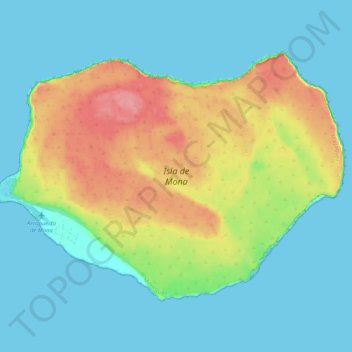
Naam: Topografische kaart Isla de Mona, hoogte, reliëf.
Locatie: Isla de Mona, Mayagüez, Puerto Rico, United States (18.05297 -67.94586 18.12185 -67.84365)
Gemiddelde hoogte: 26 m
Minimale hoogte: -1 m
Maximale hoogte: 88 m
Mona is a mainly flat plateau surrounded by sea cliffs. It is composed of dolomite and limestone with many caves found throughout. With an arid climate and untouched by human development, many endemic species inhabit the island, such as the Mona ground iguana (Cyclura cornuta stejnegeri). Its topography, ecology, and modern history are similar to that of Navassa Island, a small limestone island located in the Jamaica Channel, between Jamaica and Haiti.
Andere topografische kaarten
Klik op een kaart om zijn topografie, zijn hoogte en zijn reliëf te bekijken.
East Ridge
United States > Puerto Rico > Mayagüez
East Ridge, Sabanetas, Mayagüez, Puerto Rico, United States
Gemiddelde hoogte: 9 m
Juan Alonso
United States > Puerto Rico > Mayagüez
Juan Alonso, Mayagüez, Puerto Rico, United States
Gemiddelde hoogte: 174 m
Guanajibo
United States > Puerto Rico > Mayagüez
Guanajibo, Mayagüez, Puerto Rico, United States
Gemiddelde hoogte: 8 m
Naranjales
United States > Puerto Rico > Mayagüez
Naranjales, Mayagüez, Puerto Rico, United States
Gemiddelde hoogte: 311 m