
Topografische kaart Hagdan
Interactieve kaart
Klik op de kaart om de hoogte weer te geven.
Over deze kaart
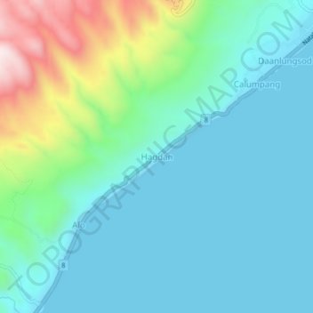
Naam: Topografische kaart Hagdan, hoogte, reliëf.
Locatie: Hagdan, Cebu, Central Visayas, Philippines (9.48031 123.38574 9.52031 123.42574)
Gemiddelde hoogte: 125 m
Minimale hoogte: 0 m
Maximale hoogte: 587 m
Andere topografische kaarten
Klik op een kaart om zijn topografie, zijn hoogte en zijn reliëf te bekijken.
Busay
Philippines > Cebu > Busay
Busay, Cebu, Central Visayas, 6000, Philippines
Gemiddelde hoogte: 225 m
Gilutongan Island
Philippines > Cebu > Lapu-Lapu
Gilutongan Island, Lapu-Lapu, Cebu, Central Visayas, Philippines
Gemiddelde hoogte: 0 m